Small swells ahead, from just about every direction
Sydney, Hunter and Illawarra Surf Forecast by Ben Matson (issued Friday 30th December)
Best Days: No amazing days but there'll be small peaky beachies Sat (NE), Tues (S), Wed (SE) and Thurs (ENE) worth your attention.
Recap: A solid NE swell reached 3-4ft at some swell magnets on Thursday, but mainly 3ft at most open beaches, smaller at south facing beaches and up into the Hunter as expected. Light NW winds prevailed across many regions throughout the day ahead of a light NE sea breeze. Wave heights have eased back to around 2ft today for the NE but some swell magnets are still pulling in occasional 2-3ft bombs. Winds are light offshore so it’s clean on top.
This weekend (Dec 31st - Jan 1st)
There’s not a lot of surf happening this weekend, but you will get wet if you’re keen.
A weak trough will move across Southern NSW on Saturday, bringing about a southerly tending south-easterly change through the late morning (earlier across the South Coast). There won’t be much strength in it until the afternoon, and ahead of it we’ll see light variable winds and consequently clean conditions - but the timing on the change is not 100% so keep this in mind.
As for surf, we’ll see today’s small persistent NE swell hang in offering just-rideable conditions at reliable swell magnets. The fetch will remain anchored off the Mid North Coast but will retreat from our all-important near swell window, so we’re looking at mainly weak sideband energy, up to a slow, inconsistent 2ft at NE swell magnets and smaller elsewhere (such as south facing beaches, and across the Hunter).
A small belt of W’ly winds existing eastern Bass Strait have there potential to generate a very small south swell for south facing beaches on Sunday but it’s not very strong, nor very well aligned - so I’m doubtful we’ll see much more than a few stray 1ft sets.
As for leftover NE swell, there won’t be much - the fetch off the Mid North Coast will slowly ease so most southern NSW beaches will be tiny, maybe a few very stray 1ft to low chance 1-2ft sets at swell magnets if you’re super lucky. But for the most part I think that it’ll be borderline unrideable.
Most of Sunday will probably be under the influence of a leftover troughy synoptic pattern, therefore mainly light variable winds and possible sea breezes. A very late S’ly change is possible in the Far South.
Next week (Jan 2nd - Jan 6th)
The S’ly change is due into Sydney beaches close to dawn on Monday. A reasonable fetch trailing behind should whip up a small local S’ly swell, though not of any great quality - wave heights will peak late in the day with 2-3ft sets at south facing beaches though these locations will be pretty ordinary under the accompanying southerly breeze.
There won’t be much leftover NE swell by this time - a small reintensification of the N’ly fetch off the Mid North Coast late Sunday looks too small and unfavourably aligned for our coast - so expect small weak conditions for the early Monday surf at most beaches.
Tuesday will then start off with easing S’ly swell (weak 2ft+ sets at south facing beaches, smaller elsewhere, easing during the day) and mainly light to moderate E/SE winds as a high pressure system builds in the Southern Tasman Sea. We may possibly see light variable winds in the morning.
On Tuesday afternoon, a small, interesting swell is expected to reach the South Coast and may push north to Sydney and Hunter beaches late in the day - though Wednesday is a safer chance for this arrival.
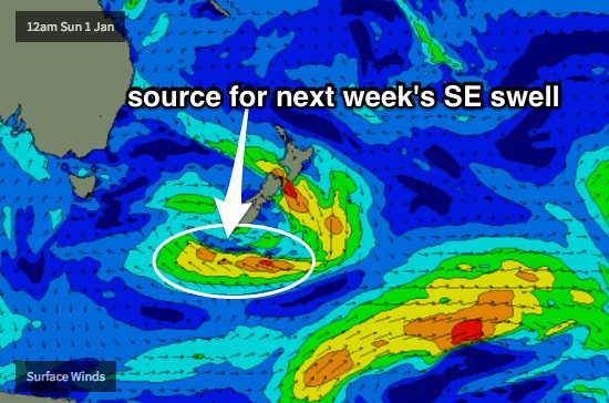
Over the weekend, a broad trough is expected to track eastwards, to the south of New Zealand, displaying a long thin E/SE fetch. Although I don’t like the eastward track, the length of the fetch and its duration within our swell window lends some credibility to the possibility of a fun SE swell pushing across Southern NSW.
Set waves could reach a very inconsistent 2-3ft from this source - as mentioned above, Wednesday is our best chance for this but we may see some action south of Sydney on Tuesday afternoon.

Again, mainly light to moderate onshore (E tending E/NE) winds are expected Wednesday but there’s a chance for a period of variable winds early morning.
Later Wednesday and into Thursday we’ll also start to see a building E/NE swell from the top of the Tasman high. This ridge will be aimed nicely into our region, and although it won’t be very strong, its sustained, near-stationary position should bump up wave heights above modelled expectations. As such by Thursday afternoon I wouldn’t be surprised if we saw occasional 2ft to almost 2-3ft sets across most open beaches from Newcastle through Sydney to the Illawarra (with smaller surf out of here owing to the fetch orientation).
A similar pattern is then expected through Friday out of the E/NE. The SE swell should be easing quickly by the end of the week (it’ll be very inconsistent anyway).
Next weekend (Jan 7th - Jan 8th)
As mentioned in Wednesday’s notes, all signs are pointing towards an extended period of E/NE activity extending from the eastward passage of the monsoon trough across northern parts of the country.
This is expected to somewhere anchor in a broad troughy pattern through the Northern Tasman Sea, resulting in fluctuating east through north-east fetches. Whilst no significant weather systems are appearing on the long term charts at this stage, all of the required atmospheric ingredients for a major swell event are certainly in position, so chances are still high that we’ll see some dynamic developments over the coming week or two.
More on this in Monday’s update.


Comments
Still some small fun waves across open Sydney beaches.
Bomb set at Maroubra this AM.
Couple of small peaks at Manly too.