Plenty of S'ly swell for the foreseeable future
Sydney, Hunter and Illawarra Surf Forecast by Ben Matson (issued Friday 25th November)
Sign up to Swellnet’s newsletter and receive the Sydney/Hunter/Illawarra Forecaster Notes and latest news sent directly to your inbox. Upon signup you'll also enter the draw to win a surf trip to P-Pass for you and a mate. It doesn’t get much easier so click HERE to sign up now.
Best Days: Sat/Sun/Mon: good series of S'ly swells peaking Sunday a'noon, with favourable winds early mornings. Tues/Wed/Thurs: more S'ly swell, with tricky winds. Thurs: building NE windswell, local winds may wreck conditions. Fri: easing NE swell and offshore winds.
Recap: Building S’ly swell on Thursday was mainly sourced from a short range fetch behind Wednesday's front, however a better, longer period S/SE groundswell filled in today originating from a Tasman Low that formed east of Tasmania yesterday (associated with the front). South facing beaches have seen strong 4-5ft sets (as per the image below) with bigger bombs across the Hunter. Early light onshore winds persisted until about 11am, with moderate SE winds holding through the afternoon.


Long groundswell lines at Bondi this afternoon
This weekend (Nov 26th - 27th)
Looks like an active weekend out of the south.
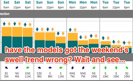
I’m still holding firm with my view that the models have got the swell trend slightly arse-about. The current S/SE groundswell will fade overnight, to be replaced by a moderate S’ly swell on Saturday, originating from strong frontal activity through the lower Tasman Sea (merging with the Tasman low).
Our model is estimating 5ft sets at south facing beaches for all of Saturday but I think it’ll be closer to 3-4ft, with smaller surf at beaches not open to the south (however the Hunter should pick up another foot or two). Either way conditions are looking pretty good with light variable winds and sea breezes.
A second, stronger front will enter the lower Tasman Sea on Saturday, and although a little less favourably aligned, will display stronger winds on a very active sea state and will thus generate larger swell periods, pushing up the Southern NSW coast during the day.
This should build from 3-4ft during the morning up to 4-5ft throughout the afternoon (south facing beaches) with bigger waves once again across the Hunter for the late session. As always, locations not exposed to the south will be smaller.
A weak troughy pattern will linger across the region on Sunday, delivering mainly light to moderate onshore winds though periods of light offshores are possible early morning.

Next week (Nov 28th onwards)
Still no changes to early next week either.
The models are still suggesting the parent low to the weekend’s frontal progression will remain slow moving south of New Zealand over the weekend, and in doing so will display a stationary S/SW fetch that (despite not being very well aligned) should generate a small spread of long period S/SE swell for later Monday or Tuesday. The models are still not picking this up well, but it’s plausible for south facing beaches to pick up stray 2-3ft sets.
Prior to that, early Monday should see Sunday’s late pulse ease steadily throughout the day, from early 3-4ft sets at south facing beaches (bigger in the Hunter) down to 2-3ft by lunchtime and into the afternoon. Expect smaller waves at remaining beaches. Set waves will be inconsistent too, owing to the less favourable fetch orientation.
Local winds on Monday look tricky under this lingering trough, with a shallow southerly change pushing up the coast during the day - probably not reaching Sydney until very late. Ahead (and to the north) of the trough, winds will be northerly, then variable - so Monday is likely to be a mixed bag with inconsistent, easing sets and difficult winds. There’s certainly some potential for a few windows of opportunity though.
Aside from the low confidence S/SE swell late Mon/Tues, we should also see another small flush of south swell around the middle of the week, from a small cut-off low that’s track from beneath Tasmania’s swell shadow on Monday. At this stage the leading edge is due into the South Coast later Wednesday, with an arrival across Sydney locations overnight into Thursday morning, and set waves should reach the 2-3ft+ mark at south facing beaches.
Otherwise, Thursday is shaping up to deliver plenty of short range NE swell as a large high in the eastern Tasman ridges up against a trough over inland NSW, strengthening NE winds off the coastal margin. A westerly change will arrive around Friday so fingers crossed we see the timing of the change just before dawn, so as to capitalise on the size and conditions (rather than a peak in swell overnight Thursday).
Looking further ahead and I’m keeping my eye on a tropical system in the Coral Sea that is showing signs of a slow, steady southwards trend across the New Caledonian region next week, and could be a NE swell producer for Southern NSW sometime later next weekend or early the following week. More on this in Monday’s notes.
Have a great weekend!


Comments
I usually put November as the least likely month of all to produce good waves but this year has been a stand out
So, the models have overcalled Saturday at least - no way it's 5ft at south facing beaches (looks 3-4ft to me). Nice lines out of the south though.
Let's see how tomorrow pans out!
Looks like my expectation that the models had the weekend swell trend arse-about has proven correct.
Here's a bomb at Bondi a few minutes ago, easy 4ft+:
And for size reference, a smaller wave a few minutes earlier:
That south swell is hanging in there nicely, solid 3ft to almost 3-4ft sets this morning, four or five waves to a set at times.