Fun swell combo for Thurs; solid S'ly swells for Fri, Sat, Sun
Sydney, Hunter and Illawarra Surf Forecast by Ben Matson (issued Wednesday 23rd November)
Sign up to Swellnet’s newsletter and receive the Sydney/Hunter/Illawarra Forecaster Notes and latest news sent directly to your inbox. Upon signup you'll also enter the draw to win a surf trip to P-Pass for you and a mate. It doesn’t get much easier so click HERE to sign up now.
Best Days: Thurs: combo of fun E/NE swell and building S'ly swell, mainly SW thru' S'ly winds. Fri: strong S/SE and easing NE swells with mainly light winds and sea breezes. Sat/Sun: rebuilding S'ly swells peaking Sunday a'noon, with good winds early.
Recap: Tuesday delivered an easing S’ly swell and a building NE windswell, the latter of which reached a peak overnight and eased this morning with early 3ft+ sets. A small E/NE mid range swell is now filling in beneath the easing NE swell, and a gusty southerly change is pushing up the coast, having reached the Sydney region early afternoon.
This week (Nov 24th - 25th)
The E/NE swell building across the region has produced some pretty solid waves across SE Qld and Far Northern NSW today with sets in the 4-6ft range. We’re looking at much smaller surf from this source in Southern NSW, due to the less favourably aligned fetch, probably reaching 2-3ft at NE facing beaches through Thursday.
However the primary swell in the water on Thursday will be a building short range southerly swell linked to the trailing fetch behind today’s change. This is related to a developing Tasman low east of Tasmania, which will generate a better quality groundswell for Friday, displaying longer wavelengths.
Thursday’s increase will be accompanied by fresh S/SW tending S’ly winds (possibly SW in a few localised areas early morning). Set waves will max out in the afternoon with 3-5ft sets; it’ll be smaller at dawn and no major quality is expected in general related ot the south swell. Beaches not open to the south will see a small mix of S'ly and E/NE swells, and better conditions under the prevailing southerly breeze.
The models have tightened up the strength of the developing Tasman low on Thursday, and aligned it a little closer to the mainland, which has ever-so-slightly upped the size potential for Friday. South facing beaches should see set waves somewhere between 4ft and maybe 6ft through the morning, with a possible slight easing trend into the afternoon. Swell direction will be mainly S/SE so there'll be quite a wide range in size across the coast. Expect a few bigger bombs across the northern Hunter.
The good news is that the Tasman low will track eastwards on Friday, resulting in a weak pressure gradient across the coastal margin which should veer winds around to a light westerly. A shallow S’ly change associated with a front traversing the southern Tasman may clip the southern coastal regions during the day but no major strength is expected.
Thursday’s E/NE swell will still be present in the water on Friday though it’ll also be easing slowly in size, and therefore won’t contribute much more size at NE facing beaches than the refracted S’ly swell. Still, it should help to peak up the beach breaks in otherwise bankless environments.
This weekend (Nov 26th - 27th)
We've still got plenty of south swell for the weekend. If anything there’s been a minor upgrade for Saturday and a minor downgrade for Sunday, from Wednesday's notes.
Strong SW winds south of the Tasman Sea on Friday - associated with a vigorous frontal passage merging with the Tasman low - are expected to renew S’ly swell for Saturday. A second, stronger (but less favourably aligned) front through the southern Tasman Sea on Saturday will then set up a slightly bigger S’ly swell for Sunday.
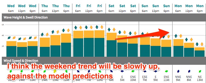
The models aren’t resolving the multiple south swell trains very well, and (in my opinion) they’ve got the trend arse-about at the moment: 3-5ft at south facing beaches early Saturday morning, easing to 3ft by Sunday afternoon.
I think Saturday is more likely to see 3-4ft surf at south facing beaches, with Sunday morning a similar size ahead of the second groundswell that should bump up wave heights to 3-5ft at south facing beaches after lunch, holding through the last few hours of the day.
As always, expect smaller surf at remaining locations and very small waves inside protected southern corners.
Local winds look generally good under a troughy pattern - mainly light variable winds and sea breeze both days though the onshores could become a little more prominent on Sunday, as per the latest mode guidance firming the trough up. Let’s see how the models are looking on Friday.

Next week (Nov 28th onwards)
The parent low to the weekend’s frontal progression is expected to remain slow moving south of New Zealand over the weekend, and in doing so will display a stationary S/SW fetch that (despite not being very well aligned) should generate a small spread of long period S/SE swell for later Monday or Tuesday.
The models are not picking this up well, so I’m speculating on this event - but it’s plausible for south facing beaches to pick up stray 2-3ft sets. Let’s revise on Friday.
Otherwise, variable winds under a local troughy pattern will create mixed conditions early next week, ahead of a series of moderate fronts through the lower Tasman Sea from about Tuesday onwards, that should supply small to (possibly) moderate south swell through the second half of next week.
See you on Friday for an update on all of these swells!


Comments
Strong lines at Bondi this morning.