Small south swells to finish the week, with renewal due on Sunday
Sydney, Hunter and Illawarra Surf Forecast by Ben Matson (issued Wednesday 14th September)
Best Days: Thurs/Fri: small, intermittent S'ly swells with mainly good winds. Sun: better S'ly swell with good winds early morning.
Recap: Small conditions have prevailed across Southern NSW over the last few days. A minor S’ly swell pushed across the region on Tuesday afternoon with peak swell periods nudging 15-16 seconds but set waves only managed 1-2ft or so (bigger across the Hunter). Similarly small, lacklustre waves have padded out today and buoy data to the south (i.e. Eden) suggests this trend will continue into the afternoon.
This week (Thursday 15th - Friday 16th)
Today's small S’ly swell is coming in below expectations, so it’s hard to gauge how the next few days of similar swell activity will pan out.
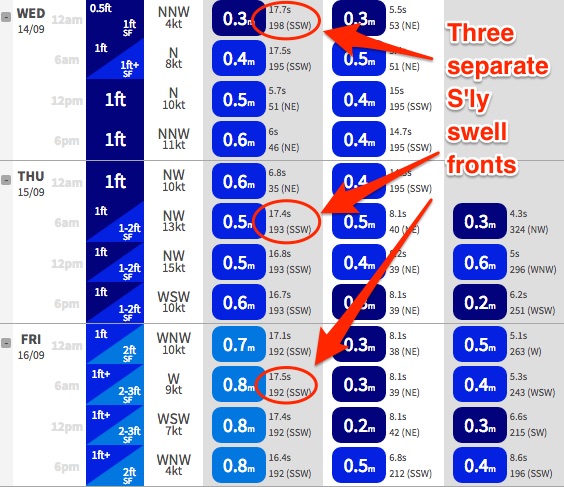
 Comparing model guidance from today to tomorrow (from the Northern Beaches forecast page), and the periods associated with the current initial pulse at 17.7 seconds (midnight) are expected to fall away steady today, with swell heights remaining around 0.4m.
Another forecast pulse of long period swell (17.4 seconds) is due in Sydney around 6am Thursday but with incrementally higher swell heights (0.5m). And then Friday has a third S’ly swell at 17.4 seconds, but with swell heights increasing to 0.8m.
Based on the raw swell data we’d ordinarily expect Thursday to mirror today’s waves however I still think there’s a chance for slightly higher surf size across exposed swell magnets. The system responsible for this swell was working on an active sea state (a characteristic lacked by the front that generated today’s swell source) and this marginally bumps up size prospects. But only a very small amount, maybe some rare 2-3ft bombs at south facing beaches from time to time, but with an overall underlying swell of 1-2ft.
Conditions will be very clean with moderate W/NW winds on Thursday. Expect much smaller surf elsewhere (a little bigger in the northern Hunter, though equally inconsistent).
Friday on the other hand has slightly bigger long period S’ly swell on the cards plus a short range S’ly swell from a low/front pushing east of Bass Strait on Thursday. This system has unfortunately been downgraded quite a bit since Monday’s model runs so the resulting swell will be a lot smaller.
Wave heights should come in around the 2-3ft+ mark at south facing beaches, and I’m once again expecting very inconsistent set waves - though probably not as infrequent as Thursday. Keep in mind that beaches not open to the south will be much, much smaller - though the northern Hunter will pick up bigger waves. Surface conditions will be very clean though with light W’ly winds.
This weekend (Saturday 17th - Sunday 18th)
Freshening W/NW winds on Saturday will maintain clean conditions across the Southern NSW coast but the only swell in the water will be easing S'ly energy from Friday with 1-2ft sets at south facing beaches, and much smaller surf elsewhere. Expect an easing trend during the day.
Sunday has had an about-face in the surf outlook with a strong new front expected to push north-east from Tasmania on Saturday, and this should kick up a new S’ly swell for Sunday. Early morning wave heights should be in the 2-3ft range at south facing beaches, with a peak expected into the afternoon with 3-4ft sets (bigger in the Hunter, but smaller at beaches not open to the south).
Sunday’s winds look slightly dicey but should offer a window of early westerlies before moderate SW tending S/SW winds develop throughout the day.
So, not a perfect forecast - but there’ll be waves around. Well worth booking in a session sometime on Sunday at this stage.
Next week (Monday 19th onwards)
The start of next week looks like it’ll begin with easing S’ly swell from Sunday, along with light winds and a north-easterly sea breeze.
On Tuesday, an approaching front will strengthen northerly winds about the coast leading to a peaky NE swell that should reach 3ft at NE facing beaches (bigger across the South Coast) however conditions will probably remain bumpy all day as an expected W’ly change is not due until overnight.
Wednesday looks like being nice and clean in the post-frontal airstream but with declining NE windswells.
Looking further ahead and a more complex troughy pattern is expected to develop over south-eastern Australia mid-week, and this could lead to the evolution of a much more significant swell generating system later in the week - though I’m not entirely sure whether this will be within Southern NSW’s swell window (model guidance is split either side of the Tasmanian divide right now). But, it’s certainly a dynamic pattern that’ll be eagerly watched over the coming model updates. More on this in Friday’s update.


Comments
Ben how confident are you on Sunday's swell? Thinking about a trip to the Hunter. Cheers
Winds look pretty tricky for the Hunter, based on current guidance I wouldn't travel there for it. Let's see how the next few updates look though.
Cheers Ben, looks like a Sunday dawn might come in undersized?
The small south swell is showing up nicely at Queensie this afternoon (can see a small delineation down the line from the NE windswell too).
Good sets across Bondi.
Craig just sent this through from Curly: solid 3ft sets.