Slim pickings in Southern NSW
Sydney, Hunter and Illawarra Surf Forecast by Ben Matson (issued Wednesday 10th August)
Best Days: Fri: if you're desperate, there should be a small S'ly and SE swell combo at exposed beaches. Sun: small new S'ly swell. Mon: stronger S'ly groundswell.
Recap: Tuesday saw a relatively stable swell trend throughout the day, with only a minor easing in SE swell before a small reinforcing S/SE swell arrived into the afternoon. Set waves managed 2ft+ for much of the day and conditions were clean with light offshore winds. Today has seen marginally smaller, but noticeably weaker surf that’s dwindled in size throughout the day.
This week (Thurs 11th - Fri 12th August)
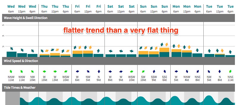
Thursday looks tiny across most stretches, if not completely flat.
Our current swell sources are expected to ease further overnight, and a front pushing into the lower Tasman Sea looks a little less favourably aligned than Monday’s notes suggested, with a later arrival too. I am doubtful that there'll be anyrthing worthwhile at all - so keep your expectations in check.
This small south swell should push up into Friday morning - I’m not terribly confident on size, strength or quality, but I am confident that our surf forecast model is underestimating this energy. South swell magnets should pick up around 2ft of average mid-range swell, maybe even a few rogue 2-3ft sets from time to time (especially across the Hunter) but beaches not open to the south will be much smaller. Expect long waits between sets too.
The only other new swell source for the rest of the working week is a small low positioned across New Zealand’s North Island, which displayed a reasonable 20-30kt SE fetch off its West Coast this morning.
Unfortunately for Southern NSW surfers, this fetch is aimed up towards Northern NSW so we’re looking at small, weak sideband energy filling in throughout the day. Set waves may nudge 1-2ft at some of the region’s more reliable swell magnets - and if anything, we can expect smaller surf as you head south from Sydney. So again, keep your expectations low.
Local winds should be reasonably good on Friday, mainly light and variable before a freshening NW breeze kicks in late afternoon.
This weekend (Sat 13th - Sun 14th August)
We’re still on track for a relatively uninspiring weekend of waves.
Saturday looks small and weak, with Friday’s swells (SE and S) both easing steadily, and only favouring the swell magnets with minor surf. Conditions will be clean with freshening NW tending SW winds though.
A weak front will push into the lower Tasman Sea on Saturday morning, and this should generate a minor bump in S’ly swell for Sunday. The latest model guidance has weakened this fetch so right now I’m ballparking 2ft+ sets at south facing beaches, with much smaller surf at remaining beaches due to the swell direction.
Surface conditions are looking good for the morning with early light W/SW winds tending SW then maybe moderate S’ly during the day. However, it’s not worth too much attention at this stage.
A stronger new S’ly swell is expected on Monday and this may impact the Far South Coast (possibly up to Wollongong) in the last few hours of the day on Sunday, but Monday will probably be a safer bet for this energy in most regions.
Next week (Mon 15th August onwards)
The models have again done an about-face, with a frontal progresion expected to generate serveral new south swells early next week, downgraded in the latest output.
We still have one strong front forecast to track from underneath the Tasmanian swell shadow on Sunday morning, but I’m concerned that it’ll push through the swell window a little too fast.
This should kick up an early spike of south swell on Monday morning, somewhere between 3ft and maybe 5ft at south facing beaches (yes, our model is undercalling again at the moment) but a steady downwards trend is expected throughout the day. Let’s see how the models are resolving this on Friday, as I wouldn't be surprised if we saw a further downgrade. There's also a risk that the swell could peak very quickly overnight Sunday too.
Otherwise, the broader storm track doesn’t look too flash for next week, with a high pressure system across the Tasman shutting down our swell window(s). Distant storm activity several days prior (i.e. later this week and weekend) will generate some minor long period background S’ly swell for the first half of next week, but this will only be useful in as far as keeping the swell magnets from becoming flat after Monday’s brief pulse (through Tues/Wed).
There are suggestions into the longer term period that we’ll see a broad ridge across the Northern Tasman Sea and a small low off the North Island of New Zealand, but this is a very long time away - the resulting swells wouldn’t arrive until mid-late next week, if they eventuate at all - so we need quite a few more days before planning anything around it.
See you Friday!


Comments
Always a pleasure to read your forecast.
Looks like a bit of spearfishing is on the cards.
Ben any prediction changes to tomorrows swell? Still maybe 2ft? Cheers
Sorry mate! Was on the road yesterday and missed this.
Nice clean 2ft+ sets across south facing beaches this morning. Looks worthwhile if you can find a bank!
That small south swell ain't looking too bad at Bondi this afternoon. Sets are pushing in the 2ft to almost 3ft range.