Large and prolonged NE swell event
Sydney, Hunter and Illawarra Surf Forecast by Guy Dixon (issued Wednesday June 1st)
Best Days: Thursday and Friday morning, each day from next week for experienced surfers
Recap:
Tuesday offered workable peaks in the 2ft range (more so in the 3ft range along the Hunter), with favourable offshore breezes persisting until lunchtime. A slight drop in quality came as breezes tended southeasterly during the early afternoon, but glassed off later allowing for some workable small options.
This afternoon we have seen a small pulse of southeasterly energy, with exposed beaches offering sets in the 2-3ft range, smaller elsewhere. The more exposed south facing beaches lost quality breifly as breezes swung southeasterly with a few passing showers, but have since cleaned up.
This week (Thursday 2nd - Friday 3rd):
A southerly fetch which has been intensifying over central parts of the Tasman Sea has projected towards the NSW coast overnight is due to provide a fun pulse of southeasterly swell on Thursday, with sets building to around 3ft+ at exposed spots by the afternoon, larger across the Hunter.
Residual energy will fade from the 2-3ft range on Friday, with no decent indications of fresh swell building before the weekend.
Early each morning holds the best chance for a clean wave under light southwesterly breezes, tending southerly and becoming susceptible to tending southeasterly in the afternoon, although quite light.
This weekend (Saturday 4th - Sunday 5th):
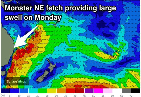
In contrast to the end of the week, models are still gunning for an oversized northeasterly swell to build late on the weekend generated a northeasterly fetch stretching all the way to the islands of the South Pacific.
This broad and elongated northeasterly fetch should already be steering 35-40kt winds right into the NSW coast by late on Saturday evening, causing the swell to build to a choppy, low quality 4-5ft by the late afternoon, perhaps larger after dark.
The surf should continue to build throughout Sunday to the 6-8ft range as this fetch intensifies despite pushing offshore slightly. Quality is still up in the air, with models struggling to agree on a scenario. At this stage, Sunday will most likely be lacking shape under an onshore breeze, with only the outside chance of an offshore airflow, most likely along the Hunter late in the day. I wouldn’t put too much faith in finding a decent wave - next week holds better prospects.
Next week (Monday 5th onward):
 This large scale system is forecast to intensify further, becoming similar to a setup we saw nearly a decade ago, that being around 2007. Core winds of up to 50kts are on the cards for late Sunday evening and into Monday morning, projecting towards the far south coast of NSW. This strong intensification should provide the strongest pulse of the event for Monday, with solid sets in the 8-10ft+ range at exposed spots along the Sydney/Hunter coast, larger further south.
One of the more interesting aspects of this swell event is its duration. Strong and elongated fetches look to remain established over the Tasman Sea and South Pacific, despite drifting eastward slightly.
Multiple intensifications around small lows developing within the broader flow will maintain regular pulses, providing strong pulses on Tuesday and Wednesday.
The surf shouldn’t drop below 6ft for the first half of next week, pulsing to 8ft at times as each swell front fills in.
Virtually the first half of next week is looking great in terms of quality. Breezes look to swing between west/southwesterly and west/northwesterly on Monday, Tuesday and Wednesday keeping most options clean and groomed. There should be plenty of solid, good quality waves to be had but only for experienced surfers.
More detail on Friday.


Comments
"The surf shouldn’t drop below 6ft for the first half of next week, pulsing to 8ft at times as each swell front fills in."
The kind of event that can punch significant holes in even the most well stacked quiver.
Might time the RDO for the latter half of the swell then - that big south swell already did a number on my fiberglass stocks!
Punch my quiver, swell! Punch it all you want!!!
Hopefully the fetch doesn't affect surface quality too badly, other than that it's still better than a S'ly
Anyone got a copy of Mark Warren's Surfing Atlas? (just saying, ducks for cover)
hahaha
hopefully it will wash all that sand currently lying on the beaches out to the banks
Have aired the same opinion on the forums maka. Huge amounts of sand on my local at the moment
Think i might work from home next week ;)
Is this going to be decent size in the Harbour open spots given ideal direction and 6m swell? Should be a few place that will take a easterly too.
Does anyone agree that Sunday will be one of the better days with 8ft surf and currently the wind has changed from NE to WNW winds throughout the day?....
depends when the swell hits, it'll need time to sort itself out from the preceding northerlies/nor easter. synoptics are still a bit funky, wait till tomorrow night/sat morning before making a call from the models.
"The surf shouldn’t drop below 6ft for the first half of next week.."
Not as confident as Guy about this lasting for that long at that size, although it does look like energy in the water for most of the week, and westerly quadrant winds pretty much all week.
Has that feel of the time of year where things can move around quite quickly, but whatever happens it looks like a lot of weather and surf coming our way.