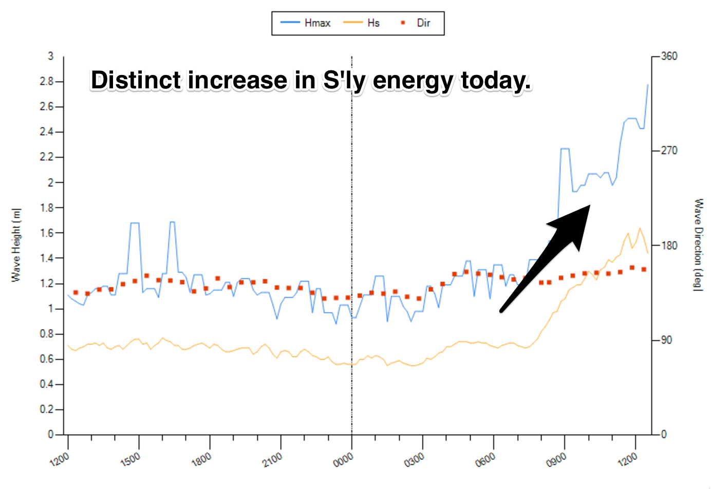
We have seen a distinct lift in southerly energy across south facing beaches this morning however, generated by a system which passed to the south overnight.
We have been seeing sets breaking in the 2-3ft range are breaking across the magnets, with winds remaining light despite swinging onshore.
This week (Tuesday 17th - Friday 21st):
A second pulse off generated by more distant fetches off last night’s system should provide more size during the overnight hours this everning. As day breaks on Tuesday, the swell should be on the downward trend from around 2ft.
Conditions should remain generally clean and workable under a light northwesterly breeze, easing and tending west/northwesterly into the afternoon, with only the slight chance of a light seabreeze.
A strong low then looks to much over the nation’s southeast, at first steering a west/northwesterly tending westerly fetch through Bass Strait, followed by a southwesterly fetch off the back side of the low. Despite being a fairly sizeable system, there are a few limiting factors.
Firstly, the alignment of the westerly fetches at the head of the system are pretty ordinary, and the spread of southerly energy up the NSW is likely to move north of the Hunter Coast, leaving coasts further south disappointed (similar to what we saw last week).
The southwesterly fetches would usually be more promising, however this system looks to move across the southern swell window fairly rapidly, leaving limited time for decent swell generation. Before we know it, the main swell generating fetches will be in our distant swell window, with worsening alignment to the coast.
Nevertheless, the initial swell front should be in the water on Wednesday morning, providing options in the 2ft+ range at south facing beaches, with more size across the Hunter. The second pulse off the more distant fetches should fill in on dark, likely peaking overnight. By the time Thursday rolls around, sets should be fading from the 2ft range.
Wednesday morning looks to remain clean under west/southwesterly breeze, before giving way to a northeasterly seabreeze later. A westerly airflow is likely to persist throughout Thursday however, keeping conditions clean throughout the day.

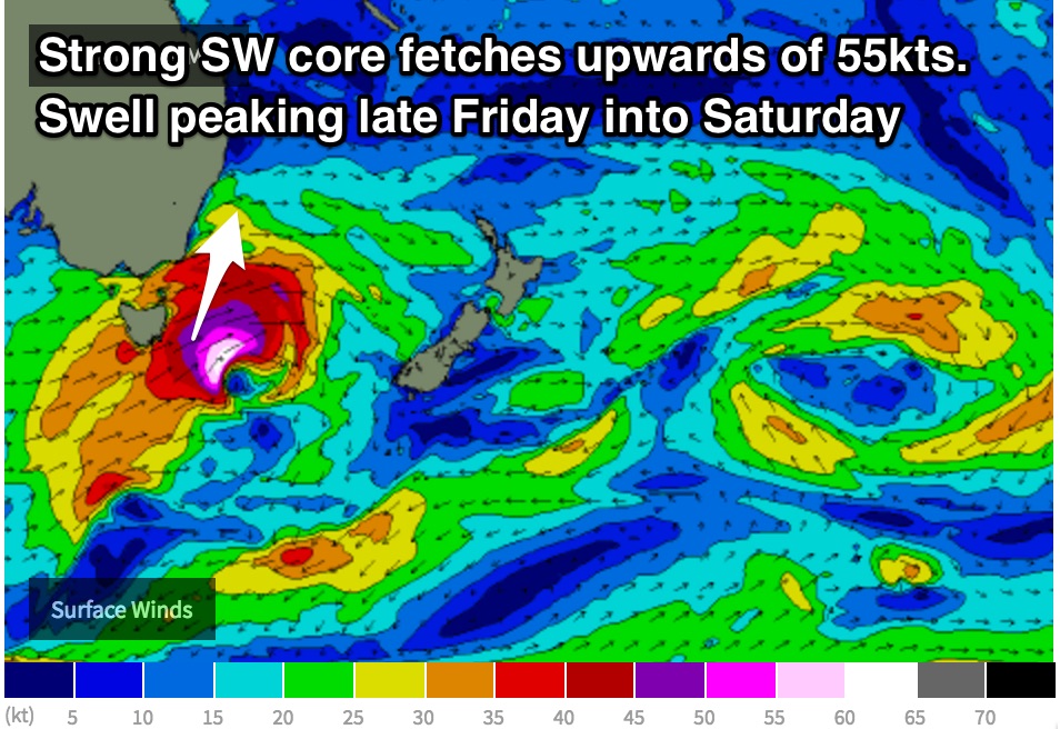
The next most significant system looks to move over Tasmania in the form of an intense low, steering southwesterly core fetches of up to 55kts southeast of Tasmania (possibly strong as it moves east into the Tasman Sea).
Finally we can look forward to a system with decent strength and alignment that is moving at a latitude far enough south to ensure that the swell will spread into the southern NSW coast.
The most recent model run has just adjusted the strength and size of the fetches down a touch while also slowing its eastward movement, however, south facing beaches are still in for some workable swell.
Two pulses are likely to move in quick succession, but as a general theme we should see south facing beaches building to a peaks in the 3-5ft range late on Friday, larger across the Hunter, likely peaking overnight.
West/southwesterly breezes should slowly swing southwesterly and eventually onshore by Friday afternoon, bringing an unfortunate impact on an otherwise good building swell.
This weekend (Saturday 22nd - Sunday 23rd):
The southwesterly trailing fetches in the wake of this system look to remain established for a lot longer than the core of the system itself, maintaining good energy into Saturday morning.
Sets should fade from the 3-5ft range at south facing beaches on Saturday morning (bigger across the Hunter but smaller elsewhere), further on Sunday from the 2-3ft range without many indications of a reinforcing swell to follow.
By this stage, a ridge should have become established over NSW, leading to generally light winds. Conditions should remain clean each morning under a westerly breeze, more so northwesterly on Sunday, preceding a northeasterly seabreeze.
The early stages of next week also look fairly dormant, so make the most of this late week pulse. More detail as the situation develops on Wednesday.


Comments
All these westerly systems suck. I was always under the impression
that these west systems were more August September .
I have a really bad really, really bad feeling this is going to be a very
bad year for decent surf. Been pretty ordinary so far.
Check the Indo forecast till the end of May !!!
I literally don't think it could be better.
Too bad you're over it, done with it, never again.
17000 islands.......
Warm water.
Tasty food.
Guy has MHL updated there wave height charts? Keep up the amazing reports champ, loving ya work
To be completely honest, I'm not a huge fan of these charts. The data is always hours old, but I suppose it shows the general trend at a glance. Just grabbed this. It's only showing just after 12pm (currently 3:45pm).
I prefer the charts embedded above, but they only show 24 hours worth.
Thanks for the encouragement. That's always welcome!
I have struggled with MHL since they changed it 12 months ago. More the usability of it on a mobile touch screen device is terrible. Where do I access that one you like Guy?
Bookmark this bad boy.
http://wavewindtide.portauthoritynsw.com.au/Charts
Thanks
Thanks
The live wave data chart has made my week. Can't stand the MHL site, for that exact reason of being hours delayed. And yes, the new site isn't very mobile friendly what so ever. Hopefully this weeks high tide doesn't ruin Wednesdays dawn patrol small pulse.
May is supposed to be the best month for waves in Sydney and the South Coast. Well, we're halfway through it with nothing significant on the radar. And this comes off the back of two very lean months.
Worst autumn in recent memory.
If the pulses were any weaker the patient would be dead!
Arf arf!
Well the predictions for last Friday were terrific! But as usual it was Flat on the coal coast and 1-3ft pathetic shit down Shellharbour way. As for this Friday and Saturday I am not going to get my hopes up, I will make up my own mind and just go have a look. If it is good Great if is is not what is predicted, so fucking Be it! I say just look at the WAMS and make up your own mind. Meteorologists don't get it right either. You just wait and see how really good or how really full of bullshit they are.
More dismallness and downgraded swell!!! Fingers crossed indo stays pumping for the start of June!