The run of E'ly trade-swell continues
Sydney, Hunter and Illawarra Surf Forecast by Guy Dixon (issued Wednesday 27th April)
Best Days: Each morning
Recap:
We have been graced with a fun easterly swell over the past couple of days, breaking across open beaches in the 2-3ft range with particular swell magnets picking up the odd bigger set. Each morning conditions have been clean and crisp under a light offshore breeze, preceding a mid-late morning seabreeze.
This week (Thursday 28th - Friday 29th) and this weekend (Saturday 30th - Sunday 1st):
A strong blocking ridge is well established over the Tasman Sea and is deflecting any frontal activity well to the south of the NSW swell window as a result. Instead, easterly trade energy will be the most significant source of swell during the forecast period.
For those who have missed it, a stationary southeasterly fetch steered by the northern flanks of this Tasman ridge has been providing a hell of a lot of surf for northern NSW and southeast QLD for the past few days.
The easterly energy which we have been receiving further down the coast this week is as a result of this fetch - that’s right, it can spread that far south despite the poor alignment. We should continue to pick up options in the 2-3ft at open beaches on Thursday and Friday as the southern extension of the fetch still persists with relatively favourable alignment, similar to what we've seen this week.
A northwesterly breeze is on the cards for Thursday morning, leading to clean, workable conditions before swinging through northerly and eventually to the northeast. Friday should see a more north/northwesterly breeze early, swinging onshore earlier and easier.
This southeasterly flow is due to broaden and rotate in the next few days, but persisting and being reinforced by another broad trade fetch located further east. Open beaches don't look to drop below 2ft over the weekend, maybe even a touch bigger.
As an inland trough deepens, the pressure gradient along the western extent of this ridge looks to tighten, whipping up a northeasterly windswell increasing late on Friday to a peak on Saturday morning with peaks in the 2ft+ range.
Meanwhile, a small but intense frontal progression is also due to move south of Tasmania late this evening and into Thursday, but its southeastward motion and poorly aligned westerly core fetches make it a pretty ordinary source of swell.
The one redeeming feature of this system is the intense winds at it's core which have the potential to be up around the 50-55kt range, which should provide a small amount of sideband energy. Hints of southerly groundswell are due to fill in across the magnets into Saturday morning, but lacking size with occasional sets in the 1-2ft range.
A slight lift in easterly energy looks to fill in across open beaches on Sunday, easing Monday as a result of an intensification distant trades, bumping the surf back up to the 2-3ft range.
Conditions should remain clean each morning the weekend as breezes tend from the northwest each day. Saturday afternoon should see a light seabreeze, although Sunday is more likely to remain clean offshore as northwesterly breezes persist.
Next week (Monday 2nd onward):
Another day of clean waves is in order Monay morning with the easing easterly swell as light/variable-offshore breezes persist through the morning, only giving way to a light seabreeze later.
A large scale frontal progression then looks to finally displace the blocking ridge, but alignment of the swell generating fetches still remain less than ideal, so the resultant swell is looking negligible.

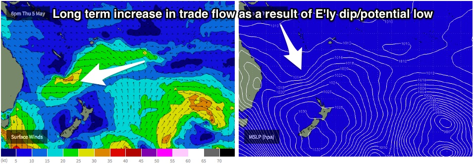
Of more importance is gradual increase in the easterly trade belt, with the latest models runs suggesting the development of a pair of dips/lows. In essence, a distant easterly trade fetch looks to intensify this time next week, providing a peak in inconsistent easterly swell for next weekend.
At this stage, the scenario looks dynamic, with limited confidence, but open beaches could pick up options in the 3ft range, with the occasional bigger set.

