Strong S'ly swell Sunday morning, plenty of surf for next week
Sydney, Hunter and Illawarra Surf Forecast by Guy Dixon (issued Friday 18th March)
Best Days: Protected southern corners until mid-next week.
Recap:
A fun southeasterly swell provided options in the 3-4ft range across exposed parts of the NSW coast yesterday, fading slightly throughout the day as a light easterly breeze came up. Today, the energy has continued to ease from the 3ft range, remaining workable at south facing beaches under a light northerly breeze. Winds have recently swung offshore preceding a change.
This weekend (Saturday 19th - Sunday 20th):
A brisk southerly change is due to move up the coast late this evening and into Saturday, associated with one of the more aggressive fronts of the season. While we are not expecting an abrupt change in wind direction or particularly strong winds to push right into the coast, we should still see a low quality southerly windswell increase to around 3-4ft at south facing beaches.
You’ll want to sacrifice some size for protection however, with southern ends of the open beaches handling the airflow best. At times, we expect to see a south/southwesterly breeze will allow for workable options, size permitting.
Sunday should see a more substantial southerly grounswell fill in generated by stronger, better aligned storm-force core fetches as this front develops into a deep cut-off low over the Tasman.
South facing beaches should offer options in the 5-6ft range throughout Sunday, fading from the 3-5ft range on Monday maintained by a south/southeasterly intensification.
As a southerly breeze continues, protected open beaches will continue to be the best options, particularly at the protected southern corners. Breezes look to swing more south/southeasterly in the afternoon, further limiting options.
Next week (Monday 21st onward):
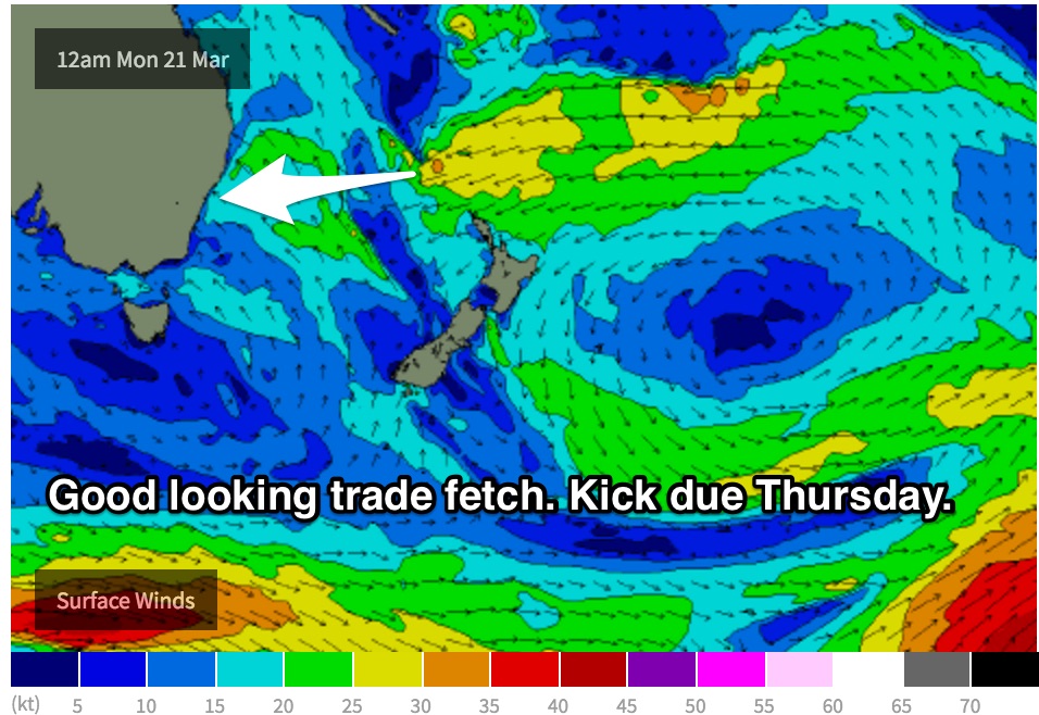
Meanwhile, an easterly trade flow has been gradually broadening and strengthening to the north of New Zealand, the effects of which should be building throughout Monday. As this energy increases, open beaches should see inconsistent sets building to around 2ft, more so to the 2-3ft range on Tuesday and Wednesday.
This fetch north of New Zealand really looks to kick into another gear on Monday by intensifying while also pushing west. A significant period pulse should fill in late on Wednesday evening, providing a decent kick into Thursday. I'm hesitant to put a size on it, but 3-5ft should be in the right ball park.
 Meanwhile, in the wake of the cut-off low which is due to develop off the coast of Tasmania, a building ridge should steer a southeasterly fetch over central parts of the Tasman from early Sunday, extending southeast towards the southern tip of New Zealand thereafter, similar to what we saw earlier this week.
Off this fetch, southeasterly energy provide ebbs and pulses between 2-3ft range early next week. This fetch looks to be at its broadest, strongest and most elongated on Tuesday, so late week southeasterly swell should coincide with a solid kick in trade energy.
South/southeasterly breezes look to persist during the early stage of next week, with the early mornings being the only chance to catch a workable wave with a brief period of south/southwesterly breezes.
Wednesday morning holds the best chance of a proper offshore breezes as winds swing light westerly preceding a seabreeze.


Comments
Westerly blowing all night
Windina ?
Zephyrus Udo;)
and bloody freezing this morn! welcome to autumn...
Autumn is here, and hows' these ASCAT images.
Swell is really gonna kick strong and large late on the South Coast, tomorrow morning will be interesting!
Fetch of Tassie..
woooo!