Fun options out of the SE and E/NE
Sydney, Hunter and Illawarra Surf Forecast by Guy Dixon (issued Wednesday 16th March)
Best Days: Thursday morning and Friday.
Recap:
A mix of east/northeasterly and southerly energy has been breaking across the NSW coast since yesterday, with the southerly element tending more southeasterly and building into this afternoon. For the most part, most beaches having been offering set waves in the 3ft range, with clean conditions at times across open beaches, particularly at southern corners.
This week (Thursday 17th - Friday 18th):
Southeasterly and east/northeasterly energy will continue to be the main contributors in the surf department over the next few days.
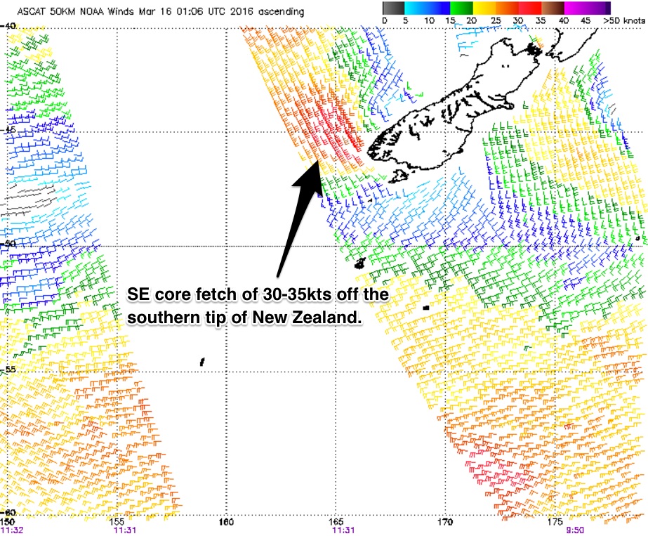
A pair of fetches have been working concurrently, firstly lets go over a southeasterly fetch which has extending from the southern tip of New Zealand towards the South Coast of NSW.
We are due to see energy increase this afternoon off this system, with southeasterly swell building to around 3-4ft range, peaking on Thursday morning with sets in the 3-4ft+ range.
With the fetch best aligned to the South Coast, this part of the state should see a touch more size, with sets more in the 4-5ft range.
A light southwesterly breeze looks to dominate during the morning, potentially tending west/southwest along selected coasts, leading to good clean options, deteriorating as a seabreeze comes in.
 Satellite passes over a slight intensification off the just off the southern tip of the South Island throughout today has been showing core fetches of 30-35kts and is expected provide a slight period pulse for Friday morning. While a kick in size is not likely, this pulse should slow an easing trend, with options fading from the 3ft+ range during the day.
A north/northwesterly airflow is on the cards during the morning, threatening to swing north/northeasterly at times during the morning, but tending offshore once again during the day as a change looms.
Meanwhile, an easterly dip just south of New Caledonia has been lingering in the past few days, but is broadening and drifting eastward. We should continue to see around ebbs and pulses of east/northeasterly energy between to around 2ft on Thursday across the open beaches, slowly fading thereafter.
As the week draws to a close, a northerly local fetch looks to increase rapidly, from about Thursday afternoon/evening preceding a change. A northerly windswell looks to increase, but due to the brief during of the gusty northerly fetch before shifting offshore, swell size should only be modest.
This weekend (Saturday 19th - Sunday 20th):
In the wake of this change, a gusty southerly breeze looks to whip up the coast from late on Friday into Saturday, generating a local windswell across south swell magnets to around 3-4ft, peaking in the morning.
Due to the local nature of this swell generator, the quality of the surf is likely to be lacking, with only protected southern corners offering anything resembling a clean wave with the potential of winds swinging south/southwesterly locally at times. At these more protected locations however, wave size will be significantly smaller, without many alternative swell sources to provide options.
Sunday should see southerly energy fade from around the 2ft range, being replaced by building southeasterly swell as the fetch swings and extends from New Zealand’s South Island, similar to today’s set up.
Meanwhile, effects from the aforementioned easterly trade fetch should fill in generated by a re-intensification north of New Zealand on Thursday. Open beaches can expect another pulse to around 2-3ft by late on Sunday, increasing further into next week.
Early breezes have the potential to tend southwesterly briefly, but soon give way to a southeasterly airflow.
Next week (Monday 21st onward):
The effects of more intense pockets within the easterly trade flow northwest of our Tasman neighbour look to fill in early next week, with trade energy building to around 3-5ft by Tuesday and Wednesday.
More details on Friday.

