Workable mix of small swell, more size next week
Sydney, Hunter and Illawarra Surf Forecast by Guy Dixon (issued Wednesday 9th March)
Best Days: Early each morning.
Recap:
Tuesday’s south swell kicked a touch harder than expect, with south swell magnets picking up some pretty solid sets in the 3-4ft range. Although light in the morning, a northerly breeze gradually swung northeasterly throughout the day, so surface conditions were never particularly clean, with the obvious exception of beaches that face virtually due south.
Today, we have continued to see fun sized surf with peaky/bumpy options in the 2-3ft range under light northerly airflow, tending northeasterly.
This week (Thursday 10th - Friday 11th):
As we come off the back of Tuesday’s southerly pulse generated by a frontal progression over the weekend, we are due to see a smaller secondary pulse generated by a broad, weaker fetch which followed soon after.
Despite lacking the intensity of the first system, these broad fetches have been working on an active sea-state and should provide a small amount of energy across south facing beaches, maintaining options in the 2-3ft range into this afternoon, fading from a similar size on Thursday.
Also in the mix today is a workable easterly swell produced by a small easterly captured fetch which moved in a perpendicular motion to the NSW coast. This swell alone is providing options in the 2-3ft range across the open beaches and is likely to ease from around the 2ft mark on Thursday.
A less significant swell source is due to peak on Thursday morning in the form of a northeast windswell, although powered. A local fetch has been hugging the coast over the past few days and looks to peak this afternoon/evening, providing small amounts of energy in the 2ft+ range to open beaches, fading thereafter.
Friday is due to see the next most significant pulses as the effects of a pair of systems fill in.
Firstly, east/northeasterly trade swell should build throughout the day generated by an increasing trade flow over the south Pacific. Open beaches should see options build to around 2ft by the afternoon.
Southerly energy should also fill in off a cut-off low which is currently approaching the southern swell window in a particular rapid motion. The most favourable fetches for the NSW coast are situated along the northern flanks of this low, and are due move into the swell window throughout this afternoon.
West/southwesterly fetches of 30-40kts look to round the corner of southeastern Tasmania later today, providing options in the 2ft+ range across south facing beaches by Friday morning.
A modest and small scale southerly breeze looks to finally become established by Thursday morning south of Sydney, much less apparent along the Central coast and Hunter until later. As a result, protected southern corners should be offering the better options, otherwise, it’s back to the north/northeasterly regime where the early morning’s look to see the best opportunity for a wave.
This weekend (Saturday 12th - Sunday 13th):
East/northeasterly swell may ease back just as touch during Saturday and Sunday morning following a brief letup of the easterly trade flow, however sets are not expected to drop below 2ft.
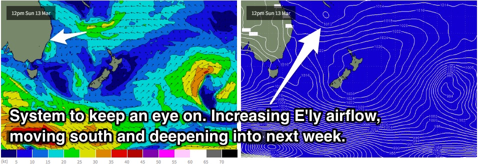
The pressure gradient then looks to tighten once again as a dip deepens just south of New Caledonia towards the end of the week, causing easterly fetches to increase leading into the weekend.
The impacts of this dip have the potential to fill in late on Sunday afternoon, more so on Monday, providing a slight increase in size across the open beaches to around 2ft+.
Meanwhile, southerly energy looks to continue filling in across south facing beaches over the weekend over small south/southeasterly off the back side of the aforementioned low. Again however, the rapid easterly motion through the swell window will hamper swell generation slightly, with around 2ft+ expected.
Next week (Monday 15th onward):
 Open beaches are looking at increasing size early next week, building to around 2-3ft later on Monday, furthermore on Tuesday as fetches gain intensity and alignment improves circulating a potential developing low.
Tuesday looks to see the next proper southerly component airflow, finally bringing an end to the relentless northerlies and potentially a decent sized southeasterly swell as a result. More detail on Friday.

