Large and clean each morning to end the week
Sydney, Hunter and Illawarra Surf Forecast by Guy Dixon (issued Wednesday 17th February)
Best Days: Thursday morning and Friday morning.
Recap:
We have seen a healthy increase in southerly and east/northeasterly energy over the past 24 hours. For the most part, Tuesday morning was in the 2-3ft range, building throughout the day to the 3ft+ range, perhaps bigger at south swell magnets.
Today, the surf has built furthermore, increasing to the 4-6ft range, larger across the Hunter. Most of this energy is filling in from the south, however east/northeasterly energy is providing around 3ft, occasionally 4ft in to the mix.
This week (Thursday 18th - Friday 19th):
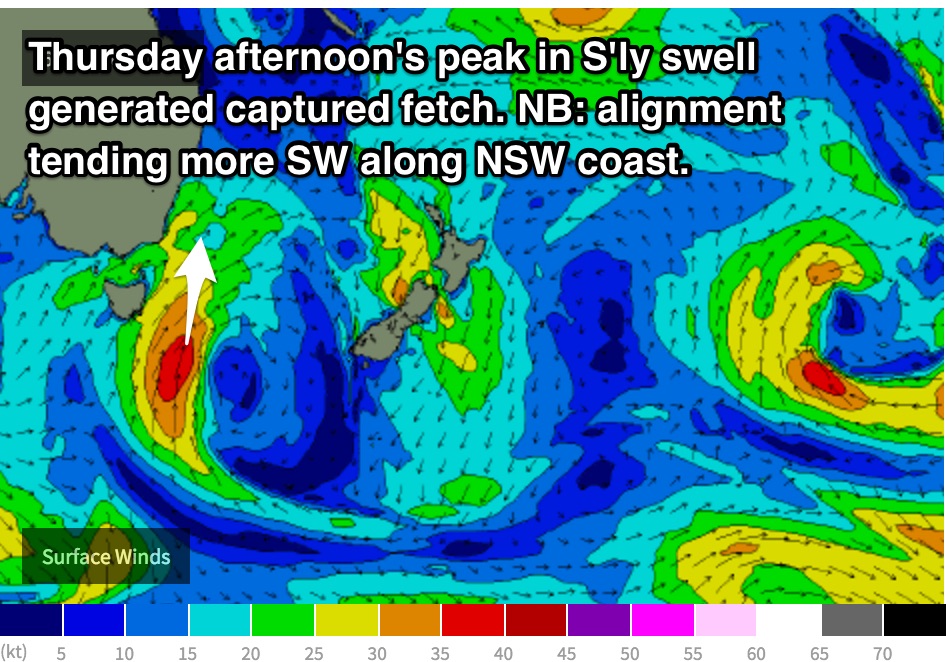
The southerly swell which we have seen build over the past 24 hours is generally short range energy which is all part of a larger scale cut-off low which has been moving over eastern parts of the Tasman Sea. The most active swell generating fetches are located along the western quadrants, steering a 35-40kt southerly captured fetch just off the east coast of Tasmania.
 The alignment of this captured southerly fetch has a small amount of westerly component, especially during the later stages of today which is not ideal for the NSW coastline. However, south facing beaches can still expect 4-6ft surf on Thursday, with a late increase to around 5-6ft (bigger at swell magnets and offshore reefs), while the shorter range energy fades.
As usual, the Hunter coast should pick up more size, potentially moving into the 6-8ft range by the late afternoon.
In comparison to the last few forecasts, the wind outlook for the morning isn’t quite as promising. There is model uncertainty regarding a very weak and small trough which may develop over the coast, having an impact on the flow of air over the NSW coast.
The early session should see clean conditions under a light southwesterly breeze (at least, some models picking westerly), before swinging south/southeasterly from mid-morning (again, some models have the change more gradual, remaining workable for longer).
In either scenario, hit it early for the best conditions/most time in the water.
This southerly groundswell is expected to fade throughout Friday from the 4-6ft range at south facing beaches, smaller elsewhere.
Meanwhile, east/northeasterly groundswell which has been generated by the tightening pressure gradient between Tropical Cyclone Winston and a strong Tasman ridge is expected provide subtle ebbs and pulses in the 3ft range, pulsing slightly on Friday.
Friday morning should still have some fun options, with the early morning offering northwesterly breezes, tending northeasterly by mid-late morning.
This weekend (Saturday 20th - 21st):
The weekend looks to be largely dominated by long range east/northeasterly groundswell, although fading as the fetch earlier in the week becomes less favourably aligned.
Open beaches should see around 2-3ft on Saturday, easing to around 2ft on Sunday.
Off the back of the cut-off low over the Tasman sea, a small southeasterly fetch looks to develop along the southern quadrants. The alignment of this fetch only looks to be aligned to the NSW coast for a short time, before tending more southerly and eventually southwesterly whilst broadening.
Nevertheless, the later stages of Saturday may still see options in the 2-3ft range across south facing beaches.
More locally, a frontal progression is expected to move south of Tasmania on Friday and although the alignment of the trailing fetches are poor, south magnets have the potential to pick up sets in the 2ft range on Sunday.
A southerly change is expected to move up the coast early on Saturday morning, likely passing Sydney at around dawn. As a result, southern corners of the open beaches looks to have the cleanest options. Sunday should have seen this breeze tend southeasterly and ease, but still leading to ordinary conditions for much of the day.
Protected southern ends may have a small wave of variable quality late in the day once breezes have dropped.
Next week (Monday 22nd onward):
By the Monday the long range east/northeast groundswell will have virtually dried up, with just residual sets in the 1-2ft range breaking along open beaches. Otherwise, background energy filling in from the southern swell windows will maintain small options in the 1-2ft range.
Light/variable-offshore breezes are on the cards early, increasing from the northeast later.
Further ahead, there are indications of Winston drifting in a southwesterly direction back into the swell window to interact with the stubborn Tasman ridge, potentially providing yet another round of long range east/northeasterly groundswell from around Tuesday/Wednesday.
At this stage, I feel fairly hesitant to make the call. Perhaps it’d be wiser to see how models play out over the coming days.


Comments
Well over 6ft at swell magnets this arvo with long straight lines that don't look like short range energy! The real size seemed to be pretty much straight east. I saw a couple of sets at The Kick that would have gone close to 6ft, DY just surfable and easy triple OH. Queenscliff bommie breaking. If the swell is going to peak tomorrow arvo it should be a sight to behold.
Just had a look at Wedding Cake Island and it is long range, long period, straight lines in the 6' - 8' range.
That ain't no short range energy.
I had thought I had got the hang of what was meant by a cut-off low, but what is showing on the charts ain't what I had thought you guys had meant in the past.
MHL buoy data for sydney showing 3 metres of swell with spikes to 6m.
Period is up over 12 seconds. Deffo not short range stuff at 12 seconds.
Putas seem to be slightly undercooking their response to this low. Winds are up to 60kms/hr over about 1000km + fetch.
Crazy swell, 10ft Deadies bombs, 6ft Winki and 4-5ft Bower, didn't expect that at all!
Also interesting to see Cronulla south didn't really look too big.
I think this first pulse has just come in stronger, and we won't see anything larger tomorrow, more so smaller.
Will have to wait and see.
Can someone please explain why some surf reports are stating 6-10ft on the north
side of Sydney and Cronulla was only 5ft. Its not April fools day?
Classic long-period swell missing some areas and focussing into others.
Watched Cronulla/Wollongong all day and was amazed to see double the size on the Northern Beaches. Crazy!
Solid in Manly still today..
hey Craig do you have any shots of deadies yesterday arvo or this morn? pretty keen to have a gander if you have some
Nah I don't sorry, was watching Winki/Bower waiting for the crowd to die for the late dash.
blew out early some spots 8ft plus
checked butterbox this morn, was maxing out. keen for the arvo sesh if that NE kicks in
lot of movement on that outside bombie good not to see a jet ski in sight for a change
It was a mixed bag for the illawarra this morning.. found a reef that was working very nicely, but wasted alot of time driving around - many of the regular spots just weren't working.
it was also one of the few times I've seen the carpark empty at the farm, total victory at sea down there, nobody game to go out
haha i was a bit wrong about being a carbon copy of yesterday morning.
hey Geoffrey, yeah it was good but disappointed to see some of my favourite breaks all messed up
Ha Cronulla finally got some swell today. Really really bad thou.
Any theory on what caused the swell kick last night?
Was from this fetch of 45-50kt S/SW winds through our swell window Tuesday morning, but even when looking at this and it's stationary nature I personally didn't think it'd get that large. Interesting Cronulla and the Gong didn't see much and it focussed purely into the Northern Beaches due to the long period nature of the swell focussing into some places and away from others.
wollongong never really excels in these south swells with the exception of 1 or 2 spots, which would be my guess as to why it didnt really pick up much of the size. half an our either side is a different story
Not saying they do, just saying the swell was nowhere near the size of the Northern Beaches, even at those exposed south facing breaks.
agreed. our south swell magnets arent really magnets anyway they just pick up more south swell than the rest of the joint.
do ya think tomorrow will be bigger than forecasted? thx lads
Probably not Alex, on the downwards trend tomorrow.
Is it still looking at NW winds in the morning? Near Bronte??
Yes, still on for NW - N/NW winds early
Any hunter report must have been 10 foot.
crew on longy bombie and queensy bombie paddle only and a SUP madman outside getting a few
Can clearly see the E/NE groundswell energy on the Thirroul cam..