Swell from every angle, winds dicey
Sydney, Hunter and Illawarra Surf Forecast by Guy Dixon (issued Monday 4th of January)
Best Days: Maybe open beaches on Thursday, possible light winds Friday morning.
Recap:
A fresh east/northeasterly groundswell graced us with its presence late on Saturday night, generated by a trough and offshore low earlier in the week. The surf built to an inconsistent 3-5ft across open beaches, with poor quality windswell maintaining options in the 3-5ft throughout Sunday.
Unfortunately, the breezes along the metro coasts limited the quality, with the only workable options during the late hours of Saturday. Conditions were much better further north under light winds.
This week (Tuesday 5th - Friday 8th):
The week ahead is looking complex to say the least, with a number of swell generating systems working hard across the northern, eastern and southern swell windows. No matter, it means plenty of swell for the east coast, we just have to dissect and make sense of it all.
 The Tasman Sea remains active off the back of late Saturday/Sunday’s pulse, with a broad fetch of 20-30kt easterly fetches persisting today steered by a ridge. Smaller, intense pockets of easterly breezes local to the Illawarra to Hunter Coasts should aid in swell generation, allowing the surf to build to the 4-5ft+ range on Tuesday.
Although easing slightly, this onshore airflow will have an impact on the quality of the surf, making it tricky to find a decent wave. I wouldn’t get your hopes up for anything epic over the next few days, as winds look to persist from the east, with an intensification developing due to a coastal trough and developing low into Wednesday.
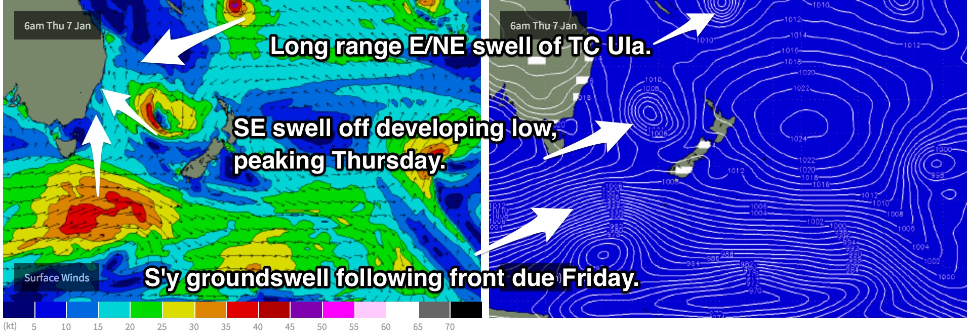
Southeasterly fetches look to increase around this developing low on Wednesday, most likely somewhere off the Mid-North Coast at this stage. As the day progresses, this system should drift south, with the fetches broadening but easing.
Underlying easterly swell should fade throughout the day, however this intensification is expected to maintain surf in the 4-5ft range for most coasts. Again, winds are not looking favourable, with gusty south/southeasterly breezes persisting throughout the day.
This low looks to be at it’s broadest on Thursday, also with the best alignment to the NSW coast. As a result, south facing beaches have the potential to build into the 6ft range by the afternoon.
The early morning session should see winds tend south/southwesterly, although remaining fairly gusty. Nevertheless, there is the potential for some good clean options across protected open beaches, before tending more south/southeasterly as the day wears on.
To further complicate things, the effects of Tropical Cyclone Ula should also come into play for late Wednesday, adding an element of inconsistent east/northeasterly groundswell to around 3ft+. While this swell should only be mere background energy, it may come in handy across the open beaches under persistent southerly component breezes.
A broad southwesterly fetch following a frontal progression also looks to move into the southern swell window throughout Thursday, providing an element of southerly groundswell for Friday. South swell magnets should see inconsistent sets in the 3-4ft range.
Early indications show the potential for early light offshore breezes on Friday morning as a ridge becomes established overhead.
This weekend (Saturday 9th - Sunday 10th):
A second pulse of southerly groundswell generated by a separate frontal progression looks to follow closely in pursuit, building across south facing beaches during Saturday. By the afternoon, we hope for sets in the 3ft+ range, slowly fading throughout Sunday.
Meanwhile, small and inconsistent options in the 2ft range should continue to break across open stretches of coastline as the impacts of Ula continue to fill in.
There is still some model uncertainty regarding the fine details of winds on the weekend, however we should see a fair chance of light/variable, possibly offshore breezes each morning.
Next week (Monday 11th onward):
Things then look to settle down for eastern Australia, with a broad and dominant ridge building over the region. We hope for more dynamic systems on the models for Wednesday forecast.

