Swell for the open beaches, breezes causing issues
Sydney, Hunter and Illawarra Surf Forecast by Guy Dixon (issued Monday 21st December)
Best Days: Each morning for an ordinary wave. Hopefully Sunday morning.
Recap:
Saturday wasn’t an overly eventful day, with a small dribble of northeasterly windswell under an increasing north/northeasterly breeze. We did see a small increase in size across the open beaches late in the day, but wind affected and sloppy.
A northeasterly swell built fairly quickly throughout the later stages of the weekend, from the 2-3ft range to the 3-4ft range by Sunday afternoon. A light northerly breeze allowed for fairly clean and workable conditions, soon tending north/northeasterly and increasing.
The surf was at its largest this morning, open beaches picking up sets in the 4ft range, occasionally bigger at select locations. Conditions were pretty raw and lumpy at most beaches, it took a bit of a hunt to find a decent peak. A very weak and shallow southerly change moved through in the early morning, but barely had an impact on conditions. Cloud and southerly breezes increased later, in the morning, whipping up a few bumps.
This week (Tuesday 22nd - Friday 25th):
Today’s peak in northeasterly windswell will fade fairly quickly throughout the day and into Tuesday. The morning session should see remnants across the open beaches in the 2ft range, easing thereafter.
Southerly breezes are also set to continue increasing this afternoon to peak late in the afternoon/early evening, albeit modest. These southerly breezes are expected to generate a small southerly windswell peaking on Tuesday morning, although lacking quality. South facing beaches should wake to wind affected peaks around the 2ft range, larger across the Hunter.
If you’re desperate for a wave, protected southern corners look to hold the best chances of a small wave away from a southeasterly breeze which could be gusty at times. Early morning is your best chance with the most left over swell and lightest winds.
Since Friday’s forecast, the scenario has changed dramatically regarding the southerly groundswell which was due on Wednesday. Core fetches at the base of today’s southerly change have been drastically down graded, lacking structure and intensity.
We will now have to rely on sideband energy off southwesterly trailing fetches which are broad, but not very well aligned and lacking strength. As a result, Wednesday should offer options in the 2ft range at south facing beaches, with the potential for the odd bigger set occasionally. As usual, the Hunter should receive more size, but without many places to hide from the breeze.
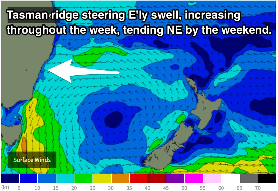
Meanwhile, a ridge over the Tasman sea will have been developing, allowing an east/southeasterly fetch to develop from about Monday, sustaining and tending northeasterly through until the end of the week. The impacts off this fetch should bode well for open beaches, with an east/northeasterly swell building to the 2ft range by Thursday afternoon and 2-3ft range by Friday afternoon.
Breezes will be the limiting factor however, remaining persistent from the east on Thursday and northeast on Friday. Early mornings will hold the best chances of a wave, although the best of an ordinary bunch.
Small southerly groundswells also look to be in the mix for the end of the week generated by small and frequent fronts passing over the southern ocean, but really only delivering options in the 2ft range to south swell magnets, larger across the Hunter.
This weekend (26th - 27th):
 The aforementioned east/northeasterly fetch will continue to build to the 3ft range across the open beaches on Saturday as the fetch swings more northeasterly. Conditions across the open beaches look to be dicey with a north/northeasterly breeze dominating the coast from late on Friday. The best chance for a wave looks to be in the morning, but really not much to look forward to.
Sunday morning on the other hand should still have plenty of northeasterly energy in the mix (from the offshore ridge in addition to the more localised increasing north/northeasterly fetch), however a southerly change looks to move through in the very early (darkness) hours of the morning. As a result, protected southern corners could be offering fun, workable peaks in the 3ft range in the morning, easing thereafter.
Next week (Monday 28th onward):
South facing beaches should see a strong increase in southerly swell into next week, initially short range energy off the local change, backed up by a solid groundswell by Tuesday. At this stage, winds aren't looking to cooperate. More details to come on Wednesday.


Comments
I sincerely hate this time of year...
#bringonautumn
Hey guy, any upgrade on the southerly swell for wed arvo? latest model runs suggesting 3ft
Sorry for the delayed response mate. At first glace, I think Monday's forecast is still holding true. We have sets in the 2ft+ range this morning at SFB, you might sneak the odd 3ft set if you're lucky. For the most part, it's modest. Working on the latest forecast as we speak. Sorry again for the late reply.
The odd 3fter was rolling through this morning. Thanks for another great year Guy and the swellnet crew. Happy holidays lads
no probs guy - thanks for the update, expectations are very low for the afternoon paddle - wish I was in vicco for xmas, looks like its pumping down there!
Yeah quality of the surf is below average. Crowds are low, find yourself an OK bank and it's alright.
cheers Alex - as long as I don't see any SUP coming towards me its all good