Dynamic week ahead. Keep an eye on Saturday morning
Sydney, Hunter and Illawarra Surf Forecast by Guy Dixon (issued Wednesday 21st October)
Best Days: Thursday morning especially further north, Saturday
Recap:
A mix of east/northeasterly energy and the remnants of Monday's southerly groundswell kept the surf in the 2ft range yesterday, with a few sets nudging the 3ft range occasionally. Although the east/northeast swell was more dominant, south facing beaches were offering the best conditions under a northeasterly breeze.
After a shaky start this morning under a north/northwesterly flow, breezes swung more northwesterly allowing conditions to improve. Open beaches have been offering fun peaks in the 2-3ft range, cleaner but smaller across south facing beaches.
This week (Thursday 22nd - Friday 23rd):
Models have drastically changed since the previous forecast, pushing the southerly change and resultant southerly pulse to Friday.

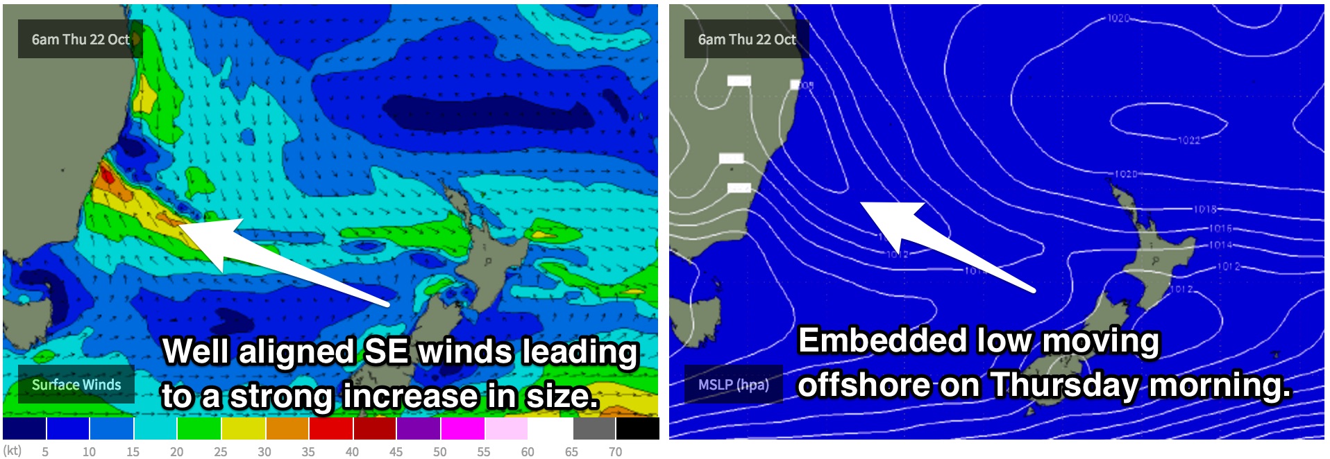
Instead of a southerly buster scenario where a rapid and distinct southerly wind change moves up the coast along trough line, we are now looking at an embedded low within this trough moving offshore on Thursday morning.
The Illawarra coast is likely to be under a southerly flow from day break on Thursday, while Sydney has a chance of seeing light variable winds for the very early session, with southerlies soon developing. Being further north, the impacts will be delayed along the Hunter, with the change of light variable winds until mid-late morning.
Winds across all coasts will progressively get stronger, causing the surf to increase in size, but the quality to decrease. Any surfable options will be limited to protected southern corners where the conditions will be much smaller, but also much cleaner.
Residual east/northeasterly and southerly energy is likely to keep the surf in the 2ft range throughout the morning, before building to a poor quality 3-4ft at south facing beaches late in the day.
Friday is likely to see the bulk of the size with south facing beaches offering bumpy wind affected surf in the 4-5ft range at south facing beaches, bigger on the Hunter, up around the 4-6ft mark.
Southerly breezes will continue to dominate the coast, although not as strong. Protected southern corners will still offer the best options for a decent wave, although be willing to sacrifice some size. These short range swells with lower periods aren’t able to refract into protected spots like a longer period groundswell can. We are likely to still see some hints of the current east/northeasterly swell at open beaches, fading from the 1-2ft mark at open beaches.
This weekend (Saturday 24th - Sunday 25th):
As the low responsible for this short range swell moves across the Tasman, swell generating breezes will ease fairly rapidly. However, weaker south/southeasterly winds passing through the periphery of the swell window will continue to add a small amount of southeast swell into the mix. In addition, a small southerly groundswell will also provide some energy for the afternoon.
South swell magnets can expect peaks in the 3ft range on Saturday morning, fading throughout the day. Like on all southerly swells, the Hunter coast is likely to highlight this energy and offer a touch more size.
Winds are looking super light and variable/offshore in the morning, so there should be plenty of workable peaks right along the coast. A northeasterly breeze is likely to increase throughout the afternoon, so set your alarm to score the first worm.
Sunday is likely to see a mix of easing east/southeasterly swell and a small southerly groundswell to 2ft at south facing beaches.
Northerly breezes are likely to increase along all coasts throughout the day, so northern corners will be the way to go. These spots will work best under a northeasterly breeze while also picking up the most size. A peaky northeasterly windswell will increase, but the quality will be pretty ordinary.
Next week (Monday 26th onward):
Next week is looking just as complex as this week, if not more.
Northerly breezes as mentioned above are expected to increase overnight Sunday whipping up a short range northeasterly windswell for Monday. Not only that, but a second subtle influx of long range southerly energy is also likely to fill in overnight Sunday into Monday. South facing beaches should hold in the 2-3ft range throughout the day, although fairly inconsistent.
The morning session has the potential for light north/northwesterly breezes tending northeasterly in the late morning. A southerly change is expected to pass through in the afternoon/evening, with yet another short range southerly swell expected to follow.
The fetch associated with this change looks to be well aligned for the Illawarra, Sydney and Hunter coasts and should cause a steady increase of south-southeasterly swell to the 4-5ft range on Tuesday.
It’ll be tricky to find a decent wave though, as southeasterly breezes are likely to dominate throughout the day. If we are lucky, we might be able to jag a sneaky period of south/southwesterly breezes early, but don’t bank on it just yet.
The situation then gets particularly interesting. Models indicate an inland trough to deepen and a strong ridge to dominate over that Tasman resulting in a tightening pressure gradient. The southeasterly fetch driving Monday’s swell will gradually tend east and through to northeast while increasing.
As a result, Wednesday has the potential to hold in the 4-5ft range from the east/northeast under a gusty northeasterly breeze. Leave some room for model flexibility however, as the situation is likely to change around in the next few days.

