A complex week ahead, Wednesday looks good
Sydney, Hunter and Illawarra Surf Forecast by Guy Dixon (issued Monday 19th October)
Best Days: Tuesday morning and Wednesday.
Recap:
Saturday offered a few workable options at open beaches. A northeasterly swell was offering peaks in the 2ft range as an initial light/moderate southerly change moved through. As the afternoon wore on, breezes eased and swung around more to the east preceding the true change that moved through after dark.
As the sun rose on Sunday, the change the previous night had made for shocking conditions. The surf was in the 1-2ft range and choppy under a southeasterly breeze. There were virtually no attractive options throughout the day.
We were graced with a fresh southerly groundswell today which has been producing sets in the 3ft range up and down the coast, nudging 4ft across the Hunter. Northeasterly winds have been dominating throughout the day, however breezes remained light enough to be allowing for fun, clean conditions for a good part of the morning. Conditions are just starting to deteriorate now as breezes increase.
This week (Tuesday 20th - Friday 23rd):
We have a complex week ahead with multiple swell sources working simultaneously. Firstly, an east/northeasterly swell generated by a tropical depression in the tropical South Pacific will fill in across open beaches throughout Tuesday offering inconsistent surf in the 2ft range.
A northerly flow is likely to dominate over the coast throughout the day, lightest in the morning. The Sydney and Illawarra coasts have the potential for an early morning northwesterly breeze, while the Hunter should be relatively clean and workable regardless.
Conditions are likely to deteriorate in the afternoon as breezes tend more northeasterly and increase.
 As we move into Wednesday, the situation becomes a touch more dynamic. The remnants of the aforementioned tropical depression are currently causing a slight increase in an east/southeasterly fetch. Core winds of 30-35kts have been recorded just to the southeast of Fiji, but despite their poor alignment, the surf should build to the 2ft to occasionally 3ft range.
In addition, a brisk northerly local fetch is likely to increase this afternoon/evening and into Wednesday morning whipping up a short range northeasterly wind swell in the 3ft range.
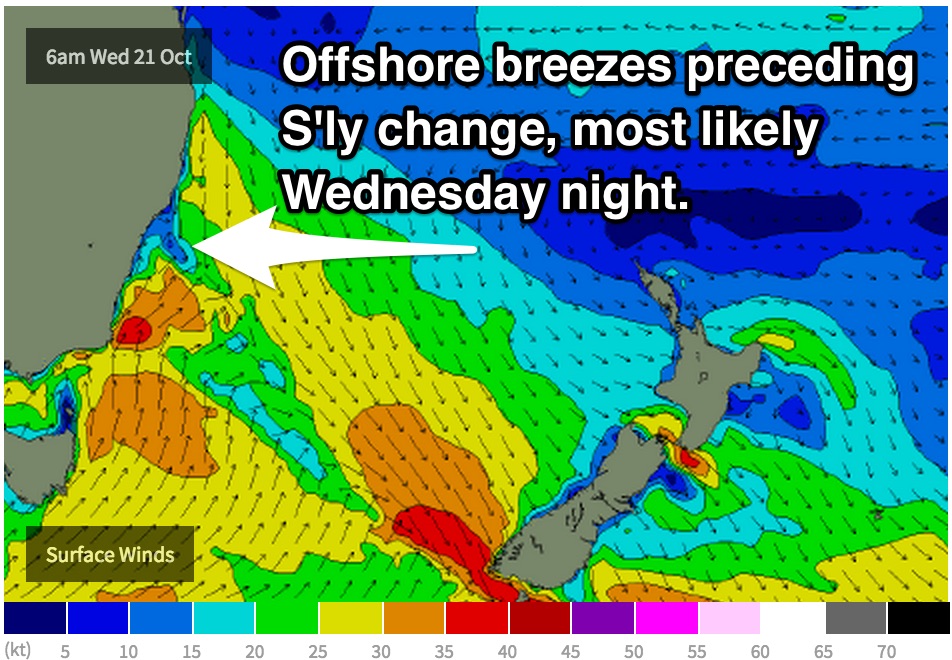
This peaky mix of swells should provide plenty of options across exposed beaches, with windows of favourable workable winds. At this stage, models are really struggling with the timing of a southerly change. Some models are backing a late afternoon/evening buster, while other have it delayed until the early hours of Thursday.
At this stage the latter scenario looks more likely, which would allow for offshore breezes in the afternoon. The morning session doesn't look as promising, with winds prevailing from the north/northwest. It should be workable, but improving with time.
I will continue to monitor the models and post any updates in the comments below on Tuesday and Wednesday.
The swell is expected to increase rapidly from the south for Thursday thanks to this change, whipping up poor quality short range southerly swell in the 4-6ft range at exposed south facing beaches and across the Hunter (obviously if the change is delayed, the increase in size will also be delayed).
Open beaches will still have a small amount of residual east/northeasterly swell in the mix and may be the best option as southerly breezes impact exposed spots.
Energy from all swell sources will fade throughout Friday allowing the surf to ease from the 4ft range. There remains a large difference in opinion between models regarding the wind scenario to end the week, so more detail will be provided in Wednesday’s notes.
This weekend (Saturday 24th - Sunday 25th):
The weekend is not likely to see much in terms of fresh energy, but instead face across all coasts. The surf is likely to hold in the 1-2ft range throughout Saturday and Sunday, preceding a possible increase in size off a poorly aligned frontal progression and short range northeasterly swell on Monday.
Pinning down the wind scenario is almost impossible and would be mere speculation at this stage with the amount of model uncertainty that we have at the moment. Sit tight and we’ll have a better idea on Wednesday.


Comments
Still a few fun lines of leftover south swell in the water at Bondi.
gday guy, have the southerly and preceding westerlies been rescheduled for a nighttime arrival? gonna miss that westerly over the lunch time hours was looking foward to it!
Yeah looks like the change has stalled. We're looking at northerlies all day today, then W'ly tending S/SW then S'ly tomorrow.
Some tidy A-frames at Newcastle this morning.