Easing trend with fun SE swell on Monday
Sydney, Hunter and Illawarra Surf Forecast by Guy Dixon (issued Friday September 25th)
Best Days: Monday: lighter winds going offshore with an early peak in SE swell.
Recap: A large and long awaited swell peaked across the region yesterday afternoon with solid sets in the 8-10ft range across exposed south facing beaches. Protected southern corners were as much as half the size and much cleaner under a southwesterly flow, although Newcastle and other exposed coasts were wind affected virtually all day. The swell has faded across all coasts this afternoon back to the 8ft range with the protected southern corners continuing to offer the best options. Generally speaking, at least for locations further south, winds have been prevailing from the south for the best part of the day, so more protection is required and the quality isn’t as good.
This weekend (Saturday 26th – Sunday 27th):
A Tasman low has been dominating our charts for the past few days and has been the main contributor of this strong swell. There haven’t been any significant other swell generating systems during this time, so the size will diminish steadily throughout the coming days.
The surf should still be solid in the 4-5ft range on Saturday morning at south facing beaches, abating slowly as the day progresses. Beaches not open to the south will be smaller, and surf size will probably taper off south of Wollongong too (but the Hunter should see occasional bigger waves, as per usual).
Although lighter than what we’ve seen in the past few days, winds will prevail from the south/southeast early, limiting options to the protected southern corners. If the last few days are anything to go by, you’ll be forced to sacrifice a lot of size for the cleanest wave, even then, it has the potential to be on the bumpy side. That being said, model guidance does have a brief period early Saturday morning where the pressure gradient relaxes, just before a reinforcing ridge strengthens south-east winds through the southern Tasman Sea, so we may see an hour or two of south-west winds at a couple of locations around dawn. But don't get your hopes up, as south-east winds will return sooner rather than later.
By Sunday, south facing beaches should have eased back to the 3-4ft range under a persistent southerly flow. Fresh southerly winds are again expected on Sunday as the ridge firms up against the coast, but a moderate south/southwesterly breeze is possible early morning, which will hopefully allow for clean and workable surf at protected locations for a period. Surf size will probably continue to ease into the middle of the day.
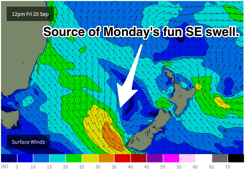
 The next swell generating system is likely to fire up this afternoon in the form of a small scale low sitting off the southern tip of New Zealand. The 30-35kt southeasterly fetch generated by this system will be working on an active sea-state allowing for faster and more efficient swell generation for around 18-24 hours. In the later stages of its life-cycle, this little system will extend a fetch over further into central/southern parts of the Tasman creating a small captured fetch. Although this swell is expected to peak overnight Sunday and into Monday morning, we should start to see a small upwards trend on Sunday afternoon with set waves pushing 3-5ft at open beaches. It's just a shame that local winds aren't looking too flash.
Next week (Monday 28th onwards):
As mentioned above, Monday morning is likely to see an early peak in SE swell before easing throughout the day. Early sets should hover somwehere between 3ft and 5ft, and winds are looking good as the ridge relaxes, offering early westerly winds then a light/moderate seabreeze kicking in throughout the day. Expect smaller surf from about mid-morning onwards.
By this stage, the aforementioned low off the New Zealand’s South Island will have done a funny tour of the Tasman on Saturday ('retrograding', which is an unusual westward track) before fizzling out on Sunday and not really providing any other noteworthy swell.
A second small low is expected to develop off the Far South Coast on Tuesday as a trough pushes in from the west, which should generate a small southerly fetch of 25-35kt winds over southern parts of the Tasman as a third low pressure centre forms east of Tasmania (assuming the GFS scenario, EC is more delayed).
Let’s be honest, it’s currently modeled to be a modestly sized system and fairly short lived, but it should provide an increase in swell to around 3-4ft at exposed south facing beaches around Wednesday. Winds are also tricky to pin down. Front running models are arguing the timing/strength of a southerly change, but in either scenario, we are likely to under a southerly component airflow from day break on Wednesday, more detail in Monday’s notes.
Otherwise, the swell windows look to be fairly quiet through the rest of the week - the most potential will be around some coastal troughiness that's expected to linger across much of eastern NSW through Wednesday and Thursday and could be the source of a brand new close range system for the end of the week, and therefore next weekend. More on this in Monday's update.


Comments
Yesterday put paid to my understanding that blueys come with NE wind.
Yeah same up here on the North Coast y'day too. Heaps of blueys around despite the ongoing southerlies.
Nice to see some offshores in Sydney this morning. Despite the early high tide, there seems to be some fun waves about the coast.
Manly on the pump!
What a painful weekend of surfing! The winds ruined all chance of a clean wave.
First weekend back surfing after recovering from a dislocated shoulder :(
Hopefully long weekend can produce some goods.