Brief weekend windows, then an onshore period of solid surf next week
Sydney, Hunter and Illawarra Surf Forecast by Ben Matson (issued Friday 21st August)
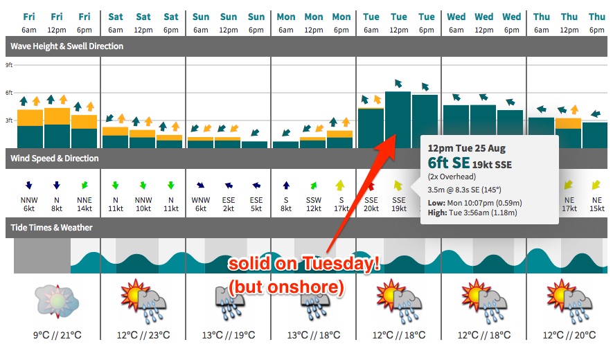
Best Days: Sat: Nice combo of easing long period S'ly swell and small peaky NE windswell; winds are tricky but we should see periods of NW'ers (prob just early). Sun: small peaky waves with variable winds. Tues onwards: plenty of swell but mainly onshore. Next weekend: chance for an ECL.
Recap: Easing S’ly swells delivered good options early Thursday at south facing beaches, before wave heights became smaller throughout the day. A new southerly swell has built in size today, kicking strongly around the middle of the day to produce 4-5ft waves at south facing beaches, and bigger bombs in the Hunter. We’ve also seen a small NE windswell in the water with 2-3ft sets at NE facing beaches.
This weekend (Aug 22 - 23)
I think the models are undercalling Saturday’s surf from both sources.
The current long period south swell will reach a peak this evening and ease overnight, but I think we’re still going to see early 3ft+ sets at south facing beaches (bigger in the Hunter) along with 2-3ft leftover NE windswell at NE facing beaches. Both sources will ease steadily during the day, so you’ll have to make the most of the early session for the most size, and there’s also a risk that local winds will freshen from the north during the day, rendering all but the most protected northern corners bumpy.
That being said, we should see a period of early NW thru’ N/NW winds across many regions, which should keep a greater percentage of beaches clean for the dawn patrol. Just keep your expectations low as there’s not a lot of confidence in how much, if any NW we’ll see in the morning airstream.
On Sunday, the southerly swell will continue to fade (1-2ft south facing beaches) however a moderate N’ly fetch anchored off the Mid North Coast should maintain inconsistent 1-2ft+ waves at NE swell magnets throughout the day. Winds are likely to be variable all day thanks to a developing trough of low pressure across the coastal margin, so there should be periods of clean conditions. However, bear in mind that ‘variable’ means ‘from any direction’ which also means we could see an onshore stream at some point.
But on the balance, Sunday should have some small peaky waves and Saturday morning looks the pick of the weekend with a great combo of easing swells and (fingers crossed) an early nor’wester.
Next week (Aug 24 onwards)
How things change! Wednesday’s forecast notes detailed a developing trough later this weekend that was likely to spin up a strong E/SE fetch aimed into the Far South of the state early next week.
The latest models are now suggesting this will develop into a closed system - possibly an East Coast Low - and therefore we’ve got a much different outlook as the resulting fetch will now be aimed straight into the Sydney region, and local winds will probably be gale force onshore at some point.
At this stage Monday morning will start off small, with a combination of minor leftover swells from the weekend (1-2ft open beaches), and winds are expected to - at some point - swing gusty S’ly as the low develops. The timing of this wind change is critical as to the afternoon’s surf prospects - if it’s delayed until mid-late afternoon, we may see small surf persist all day. But it it arrives any time before mid afternoon, we’ll see a kick in short range S/SE swell later in the day.
Best estimates currently have a moderate to fresh southerly wind change before lunchtime, and a small kick in surf to 2-3ft at south facing beaches from the middle of the afternoon onwards, with a few bigger sets right on dark - but it’ll be very bumpy under the southerly wind.
Tuesday will now probably see building short range SE swell with accompanying SE gales, south facing beaches may see 4-6ft of low quality surf and the only possible options will probably be inside protected southern corners.
This swell is then expected to ease from Wednesday onwards with winds veering to the east as a high pressure system builds from the south-west. Solid surf will persist through the middle of the week but quality is likely to remain very average under a sustained onshore pattern.
The outlook for the rest of the week suggests another trough will build along the East Coast , with an infeed of NE winds building short range NE windswell for Thursday and Friday (somewhere in the 3-4ft range), ahead of some potentially explosive developments into next weekend (or early in the following week) with a chance for another East Coast Low to develop off the Southern NSW coast.
Additionally, a series of powerful Southern Ocean lows moving through our far southern swell window will generate a series of small, long period events that'll add more complexity to the mix (the first swell around Wed/Thurs and another around Sat).
But.. this is all quite some time away - I’ll update these thoughts on Monday. Until then have a great weekend!


Comments
How's the corduroy at Newcastle later this afternoon!
Surf forecast notes are going to be a little late today (hopefully Sydney up around 7pm, SE Qld around 8pm).
But jeez, if you ever wanted a tricky forecast period, the next few days have it all. But, in short I'm quietly confident that the next few days - in particular Wednesday - will end up being very good from Sydney northwards (winds look tricky from Wollongong south). Should be plenty of size too.
Thanks Ben! Think i might roll the dice tomorrow morning with a dawn session. Wish me luck.... both in successfully getting out of bed and then finding some juicy waves.
Praying for NW / WNW winds on Wed morning!!!