A great week (or more) of southerly swell ahead
Sydney, Hunter and Illawarra Surf Forecast by Ben Matson (issued Monday 1st June)
Best Days: Tues/Wed AM: Plenty of waves, best at potected spots. WedPM/Thurs: excellent, strong S/SE swell with great winds on Thurs. Fri/Sat/Sun: really fun, pulsing S/SE swell with generally good winds.
Recap: Plenty of fun small waves all weekend, clean 2-3ft surf Saturday as the SE swell faded away, to be replaced by a clean 2ft S’ly swell on Sunday. Conditions were smooth both days with light winds. Today we’ve seen a steady increase in new south swell that’s currently 4-5ft at south facing beaches and continuing to build, albeit with fresh and gusty SW winds.
This week (June 2 - 5)
South swell will be the dominant theme for the week.
We’ve got a broad low pressure system developing in the central Tasman Sea, and a large high pressure system over South Australia is strengthening a long southerly fetch across the western flank of the Tasman low. By tonight, the low is expected to be located off the West Coast of New Zealand with the southerly fetch spanning almost two thirds of the Tasman Sea.
Initially, most of the surf we’ll see through Tuesday will be mid-range energy generated by a stationary southerly flow in our near swell window. The close proximity of this fetch to the mainland will yield a high level of consistency, but quality won’t be high and local winds will swing from the SW to the S throughout the day (pockets of W/SW winds are likely early morning). South facing beaches should see 6ft sets but it’ll be smaller at most beaches in the 3-4ft range, with smaller surf inside sheltered southern corners. Similar surf is expected through Wednesday with a slow easing trend from mid-late morning onwards.
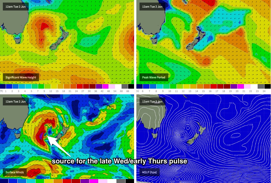
While this is occurring, a secondary centre of low pressure is expected to have developed (tonight) just north-west of New Zealand’s South Island, before wrapping into the main circulation centre, tightening the pressure gradient to the west and forming a band of 40-50kt S’ly winds at about Tasmanian latitudes (although in the eastern Tasman Sea) that are modelled to slingshot clockwise around the low - see chart below. Because this fetch will be working on an already active sea state, we should see a greater size potential from this source and it'll have a lot of strength too.
The only downside of this event is its timing. Right now the leading edge is due to arrive very late Wednesday - probably no earlier than 3-4pm - before peaking overnight and then trending downwards on Thursday. As such, either the dusk session Wednesday (low confidence) or the dawn patrol Thursday will yield the best waves from this source, probably somewhere in the 6ft+ range at open south facing beaches, with a broader coverage of size across remaining beaches due to the slightly more east component in the swell direction (S/SE). I wouldn’t be surprised to see even bigger 8ft+ sets at some of the offshore bombies that harness longer wavelengths really well (and other reliable coasts such as the Hunter region).
And, conditions are looking excellent with light W/SW winds all day. So Thursday is well worth pencilling into the diary for a sly early session before work.
Although Thursday’s swell will slowly ease throughout the day, we’re looking at only a gradual drop in size through Friday as the southerly fetch extending north from the SW tip of New Zealand’s South Island is expected to remain active during the middle of the week. Local winds should remain light all day with clean conditions, and exposed south facing beaches are likely to see anywhere between 3ft and maybe 5ft of inconsistent but quality S/SE swell. Expect smaller waves elsewhere.
This weekend (June 6 - 7)
We’ve got a great (long) weekend of waves ahead. Initially we’re looking at plenty of residual S/SE swell from the fetch off the SW tip of New Zealand’s South Island on Saturday morning, but in addition to this a series of polar front tracking N/NE through the Southern Ocean from Wednesday thru’ Friday - directly below New Zealand - will maintain similar energy through the rest of the weekend. It won’t be sizeable, but should ensure 3-4ft of S/SE swell at south facing beaches.
Local conditions look good on Saturday with an early westerly breeze however a weak front is modeled to clip the South Coast late in the afternoon, which may bring a temporary S’ly change to some parts. This will probably clear quickly to the east though, so Sunday’s winds should return back to a light westerly. We’ll also probably see a small pulse of south swell from this front later Sunday although no bigger than the pre-existing S/SE swell.
So all in all, a good weekend to high the highway for some quality country waves.
Next week (June 8 onwards)
No major patterns on the boil for next week other than a seasonal frontal progression across the south-eastern states that are likely to maintain a healthy cycle of south swells for the foreseeable future. More on this in Wednesday’s update.


Comments
Chunky at Bondi this morning!
And solid at Queensy early this morning on the sets.
Solid at Bondi this morning.
And some chunky options on the Northern Beaches around lunchtime.