Thursday is the pick of the forecast period
Sydney, Hunter and Illawarra Surf Forecast by Ben Matson (issued Wednesday 15th October)
Best Days: Thursday: rapidly improving surf - still solid at south facing beaches early - with a steadily easing south swell and winds tending offshore.
Recap: Small mix of NE and S'ly swells with light to moderate offshore winds across the Sydney basin for most of Tuesday, much longer than expected due to the developing ECL stalling off the South Coast. We did see a large kick on the South Coast, and Sydney beaches also spiked in the last few hours of the day but set waves were locally only 4-5ft+ at south facing beaches. However, storm to hurricane force S'ly winds developed along the coast overnight, delivering a memorable weather event right across the state. South facing beaches saw set waves in excess of 10ft+ this morning although wave heights are now starting to settle down. Beaches not open to the south are considerably smaller, and winds have gone SW as the low retreats from the coastal margin.
This week (Oct 16-17 onwards)
It's a simple swell trend for the rest of the working week - down, down, down.
That being said, early Thursday will still be very solid early morning with sets still likely to be near 5-6ft at south facing beaches, whilst much smaller surf will prevail at remaining open beaches and protected southern corners, due to the acute southerly swell direction.
The good news is that today's gusty winds will back right off overnight, leaving most regions with light to moderate W'ly winds, possibly even W/NW for the morning session. So conditions should improve very quickly and there's likely to be a wide range of options right across the southern NSW coast. Weak sea breezes are expected through the afternoon so aim for an early surf if you can.
Friday looks a little dicey. A shallow S/SE change is expected to push along the coast early morning, reaching southern Sydney (i.e. Wollongong thru' Cronulla) just before dawn and then through to the Northern Beaches an hour or two later, before finally reaching the Hunter shortly after that. This change will deteriorate conditions at those beaches still picking up the dying leftovers of south swell (2-3ft south facing beaches, a little bigger in the Hunter).
There's a chance for a brief window of an hour or two at dawn but I'm not confident it'll happen - keep an eye on the weather stations south of Sydney (Wattamolla, Bellambi, Kiama, Point Perpendicular etc) to track the change and with some luck it might stall in its northward trajectory. Otherwise, expect slightly wind affected leftovers for most of the day. Winds should in fact ease throughout the afternoon but it probably won't improve a great deal.
This weekend (Oct 18-19)
Still nothing major on the cards for the weekend at this stage.
We'll see a small south swell across the region on Saturday, generated by Friday's change, but it won't be very big - just the occasional 2ft set at south facing beaches (bigger in the Hunter). Conditions will be nice and clean though with early light variable winds and moderate to fresh NE sea breezes.
Sunday morning should be clean on the surface with moderate NW winds ahead of a gusty afternoon nor'easter, but surf size will remain small - just a tiny combo of leftover south swell and meagre trade swell fro a distant fetch developing north of New Zealand. Certainly not worth working around anyway.
As noted on Monday, it's definitely looking like a good weekend for the swell magnets at this stage.
Long term (Oct 20 onwards)
Next week doesn't have much excitement on the cards at this stage. A gusty southerly change is due early Monday but freshening NE winds ahead of the change should whip up a small NE windswell for the early session (this could provide some nice peaky beaches to start the working week).
At this stage the southerly change doesn't look like it'll have much behind it, so south swell prospects are minimal through the middle of the week - a small system is expected to track through the central Tasman Sea but it looks pretty weak at this stage, and unfavourably aligned for our coastline anyway.
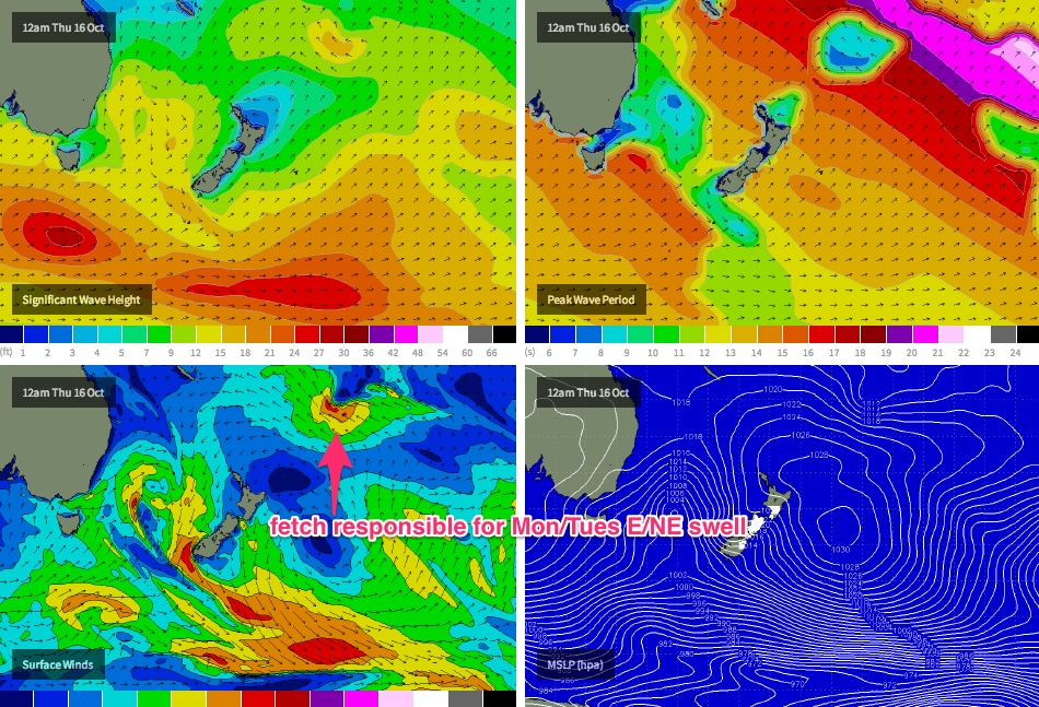
We should also see some very inconsistent but only small E/NE swell early next week (later Monday and into Tuesday) generated by a developing trough south of Fiji over the coming days (see below), however it's a long, long way from our coastline and is mainly aimed to locations north of us. As such, I'd be surprised if we saw much more than a lazy 1-2ft one-wave set at open beaches every twenty minutes or so. I'll take another pass at this on Friday with the availability of updated satellite data.
Otherwise, we're looking at a general coastal troughy pattern for the rest of the week with most of our surf prospects likely to originate from local fetches. Could be a good time to consider over activities, or other coastlines. But more on that in Friday's notes.


