Cold and windy with flukey south swells
Sydney, Hunter and Illawarra Surf Forecast by Ben Matson (issued Monday 23rd June)
Best Days: Late Wed (possibly) and (more likely) Thurs: small south swell at exposed beaches with gusty offshore winds. Fri: stronger south swell with gusty offshore winds. Sun: strong south swell with gusty offshore winds.
Recap: The weekend’s forecast played out very close to expectations. Friday’s solid S’ly swell eased through Saturday, offering inconsistent but fun waves at south facing beaches for much of the day. A new S/SE swell arrived on Sunday, delivering fun 2-3ft waves once again to south facing beaches, with bigger waves in the Hunter. This swell is now easing across the region as a vigorous weather system approaches form the west.
Next week (June 24-27)
We’ve got a windy period ahead for the entire SE region of Australia in conjunction with a major cold outbreak. In fact, apart from a temporary easing trend later this week (sometime around Thurs), a renewal of strong fronts will bring about further windy conditions from Friday right thru’ the weekend.
What’s interesting about this weather progression is its northern extent. The storm track is expected to be positioned either at Tasmanian latitudes, or across the eastern states, and this will result in two key factors for NSW’s surf potential - local winds will generally remain out of the western quadrant, and the swell window will initially extend only as far south as eastern Bass Strait. Later in the week we’ll see a fetch develop off the southern coast of Tasmania but this will still be quite constricted compared to what we usually see in this neck of the woods.
So, with the waters of eastern Bass Strait (and surrounds) being our primary swell source for the short term, we’re going to have to closely analyse the wind field across this region. Reason being - we usually need (as a bare minimum) at least a small degree of south in the westerly airstream for their to be any surf potential. In my experience there’s a very fine line where these flukey swells actually make landfall in southern NSW, and more times often than not, it’s just a couple of degrees in the swell direction that can make the difference between fun waves at exposed south swell magnets and total flatness.
One other point to consider: there is an axis point on the South Coast whereby south swells originating from eastern Bass Strait seem to refract about. This point is usually located somewhere between Ulladulla and Wollongong, and often results in tiny to flat conditions south of the axis, but increasing size to the north, biggest in the Hunter region. So whilst the forecast is rather flukey all week in southern NSW, it’s likely to be quite marginal at times in the Far South.
So on to the specifics. Strong W/NW winds today and tomorrow will render Tuesday tiny, if not flat across most southern NSW beaches - the only energy in the water will be some tiny, infrequent SE groundswell generated well to the south-east of New Zealand late last week (discussed in previous forecast notes, but generally dismissed as a source of quality surf).
A front crossing the coast late Tuesday may temporarily develop a W/SW fetch inside our acute swell window but this is expected to last for just a brief time, so I’m not expecting much surf to develop on Wednesday morning (maybe a foot plus at a handful of super south swell magnets if we're lucky).
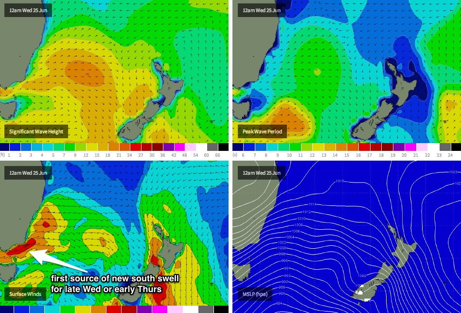
However a stronger, slightly longer lasting W/SW fetch is modelled to develop in eastern Bass Strait early Wednesday (see chart below) and this is probably our first stab at a reasonable pulse of south swell - I don’t think it’ll arrive until very late in the day on Wednesday at the earliest, with Thursday morning likely to see the most size ahead of a slow easing trend throughout the day.
Size wise, south facing beaches may pick up a few stray 2ft+ sets (unfortunately this will probably peak overnight Wednesday), with bigger surf in the Hunter. However beaches not open to the south will remain tiny to flat. Conditions will be clean but blustery with offshore gales.
On Thursday, a much more significant front - this time extending just south of Tasmania - will push into our acute south swell window, and is expected to generate a stronger southerly swell for Friday morning. This should generate 2-3ft+ waves at exposed south facing beaches (still tiny elsewhere), with bigger sets in the Hunter. Freshening W/NW winds will again maintain clean, blustery conditions at open beaches.
One thing to keep in mind though - the models have been moving the specifics of these storms around in recent model runs, and it’s hard to get a gauge on whether they’re locked in right now, as small changes could push each of these small pulses around by a half day, and also increase or decrease their size potential (due to their close source). So let’s take a look in more detail on Wednesday.
And lastly, the Bondi surfcam will be your best friend throughout this period as it’ll show the size and strength of each pulse at its full capacity (for the Sydney region anyway).
This weekend (June 28-29)
Another strong front will cross the region over the weekend, strengthening NW winds on Sunday ahead of a blustery SW change early Sunday (before winds revert back to the W/SW). This suggests Friday’s south swell will ease rapidly on Saturday (resulting in tiny clean waves) however Sunday’s new south swell could deliver 3-4ft waves at south facing beaches across Sydney and the Illawarra, with even bigger surf in the Hunter (but much smaller waves at beaches not open to the south). Let’s take a look in more detail on Wednesday.
Long term (June 30 onwards)
More fronts! More cold outbreaks! More south swell! The same pattern is expected to persist through into the first half of next week, in fact as the Long Wave Trough moves further east this could potentiallly open up the swell window to a much stronger, longer and broader southerly fetch, ultimately resulting in the biggest waves from this winter frontal progression. As such it’ll be worth getting into a routine as we’re going to see multiple days of small to (possibly) medium sized south swell throughout the coming weeks. Just make sure you’ve got some good rubber to ward off the cold.


Comments
Hey Ben, what would lead the Tsig to drop so much today? Normally that would be associated with a building windswell right...? But there's no windswell registering...
What location Mitch?
It's small N'ly windswell. You can just make it out right at the extreme top of the multi spectral plot.
Yeah Don it is a VERY small component. I was referring to the Sydney buoy, so could there be a shade of energy there even smaller and unrecognisable than the Byron buoy?
Eden clearly shows a N windswell, but the drop in Tsig was soon followed by other characteristics of the windswell, drop in TP1, direction change, etc...
Batemans Tsig has dropped much more than TP1 for almost the whole day, and now (on the graph) is hinting at the N windswell developing. Nothing on the spectral but a discrete SE groundswell.
Port Kembla was offline and might now be on the blink...
Sydney has been very similar to Batemans.
Crowdy Head was very late (sat) to register the groundswell which arrived on Friday, even it was seen on those shots from the cam.
Looks like it's pumping in Coffs right now!
Perhaps a dieing groundswell becomes so inconsistent that the Tsig drops right out, but TP1 remains fairly consistent
cc
this am
6ft - ben scale
http://s22.postimg.org/4a54dygs1/Clipboard01.jpg
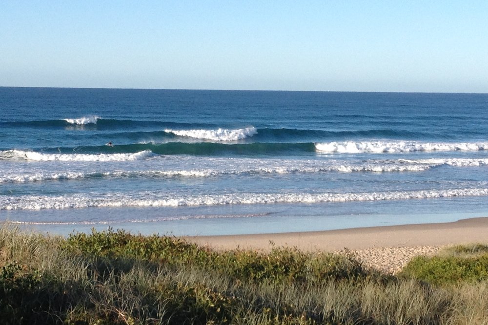
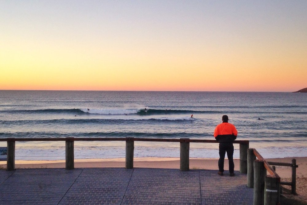
Wow.. this flukey south swell is punching well above its weight. Not bad from a gale-force W'ly tending W/SW fetch! Wave heights in the third and fourth images have to be pushing 3ft+.
Yet.. it's tiny in the Wollongong region. A classic example of the axis of refraction on the South Coast (as detailed in the notes above).
Even Cronulla isn't picking up much.. maybe 1-2ft by the looks of things.
Exactly Ben. I witnessed this many a time living down the South coast...?
This has always had me stumped as sometimes I would ring some fellas up in Syd and was uck all swell, but down south was pumping and visa versa...?
Classic
Do you know what is like down further south at the moment...? Interesting.
Depends on the weather system Welly.. really couldn't say. However I have seen the current setup happen a few times in the past (I tried to pre-empt it in my notes above, and thought I was being generous.. but obviously not generous enough!).
Funny thing is that Maroubra isn't pick up hardly any swell.. I watched the cam for ages and didn't see anything above 1.5ft. Sure, it doesn't face south but normally the northern end will pick up 60-70% of Bondi's size under a straight south swell.
You have a hard job to please all Ben, but keep a very level head.
No wonder Tommy Boy and RC use you a lot :)
Nice work.
Bathymetry is obviously playing a big part in this swell bending into certain parts of the coast and not others then. I notice no record of this swell north of Sydney either (again bending/refraction playing a big part into how much swell makes it into each nook and cranny of the coastline).
Yep, thats exactly what I think as well DW.
With a 10m swell down parts in the south, this is for sure a piece of the spectrum.....?
Refraction and bathymetry......!
Interesting.
And again this morning Sydney is sucking in some decent swell whilst locations to its north and south are tiny.
Quite amazing what Sydney/Hunter beaches are pulling from this fetch!
Yep, agree Ben. Sydney buoy is amazing compared to the buoys to its south and north.
The axis of refraction also seems to be causing problems on the North Coast.
Looks as if it's hitting the Mid North Coast OK. Shame Byron buoy isn't updating.
Port had easy 3ft sets this morning..

And Coffs looks 2-3ft.

There were some spots bigger than that too Craig. hehehehehe
Oh that's good, sounded like it was missing? Curly this morning was 2-3ft with a couple of bombs but pretty average.
No photo, I think the Byron reporter forgot to get out of bed and actually look at the surf this morning.
Today and yesterday's NB photos clearly showed a NE windswell. How come it's not in the swell train analysis?
Also, I understand why there is WSW swell in the swell train analysis, is this something that hasn't and won't be automatically removed?
That's not NE windswell, just tiny ripplets from the ocean. If it were windswell it would be breaking up the south swell lines much more noticeably. Ben had a prime example of this a week or so ago. Also check the Manly cam, there'd be little peaks breaking everywhere if there were a tiny NE windswell in the water.
Ok, not familiar with Sydney so cheers. Missed the example though. Checked the cam and nada. If they are indeed tiny ripplets, are they what's left over from what was photographed on the Ballina report a few days ago?
Interesting to look at all the swell train and surf forecasts, Port Mac 4-6ft SW. St Helens all west swells haha.
Do you think the troughs on the BoM charts are strong and tweaked directionally enough to play a role before refraction/bathymetry?
Hard to say, but def not from up North Coast, probably just tiny lines from the stiff offshores/bouncing off cliffs etc.
Yeah the strength of each system and it's position in Sydney's swell window is why Sydney north is seeing the most size, couldn't see the bathy playing a greater effect than just the swell arcing out from the W/SW fetch.
Ok cool cheers.