Slower period of small swells

Southern Tasmanian forecast by Craig Brokensha (issued Wednesday April 16th)
Best Days: Tomorrow and Friday morning, Wednesday morning
Features of the Forecast (tl;dr)
- Smaller reinforcing SW swell tomorrow with light N/NW tending variable E/NE winds
- Small inconsistent W/SW swell for Fri, easing Sat
- Moderate N/NE tending E/NE winds Fri, light N/NW tending variable Sun
- Small to moderate sized, very inconsistent W/SW groundswell building Tue PM, easing Wed
- Moderate S/SW winds Tue, N tending SE Wed
Recap
We saw small surf through yesterday morning while a strong new SW groundswell for the afternoon failed to really deliver though this morning we saw better, inconsistent 2-3ft sets across Clifton with clean conditions.
This week and next (Apr 17 - 25)
With today’s swell coming in a little under expected, the secondary pulse for tomorrow looks to probably only maintain small 1-2ft sets across Clifton, thanks to it being generated by a less favourably aimed fetch of NW gales.

Conditions should be clean most of the day with a light N/NW offshore, tending variable through the afternoon from the E/NE.
Into Friday, our inconsistent W/SW groundswell from a distant and good but northerly tracking polar low is on track, with it not expected to offer much over a slow 2ft with a reinforcing swell for Saturday morning due to come in around 1-2ft before easing.
Winds look N/NE tending E/NE through Friday with N/NW tending variable winds Saturday.
Into Sunday and early next week we’re looking at tiny surf, while the next noticeable increase in energy looks to arrive Tuesday afternoon, peaking later if not Wednesday.
This swell will be a very long-range and inconsistent W/SW groundswell, generated by a strong, mutli-staged low that’s formed to the south of South Africa.
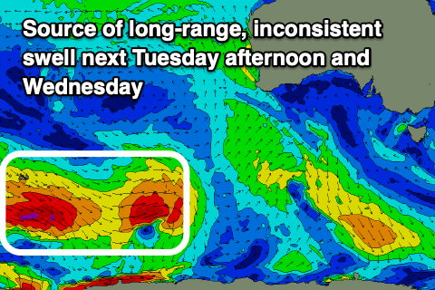
An initial fetch of very distant, gale to severe-gales has now weakened, but a secondary polar front pushing up over the back of the initial low today is generating an additional fetch of gale to severe-gale W/NW winds that will project to about the Heard Island region tomorrow before weakening into the afternoon.
The swell will then have to travel towards us, losing size and consistent with it only likely to peak at an inconsistent 2ft+ across Clifton later Tuesday and Wednesday.
Unfortunately a trough moving through Monday looks to leave lingering S’ly winds Tuesday, clean Wednesday morning but we’ll confirm this on Friday as the models are still struggling to resolve troughiness in the region.