Make the most of the coming days before things slow from mid-week

Southern Tasmanian forecast by Craig Brokensha (issued Wednesday April 9th)
Best Days: Tomorrow, Saturday morning, Sunday morning, Tuesday morning
Features of the Forecast (tl;dr)
- Fun, reinforcing SW groundswell tomorrow AM, easing with N/NW winds
- Moderate sized W'ly swell building Fri with W/SW tending S/SW then S/SE winds (W/NW breezes likely early)
- Easing moderate sized W/SW swell Sat with N/NW winds ahead of a shallow S/SE change into the PM
- Easing surf Sun with similar winds to Sat
- Fun reinforcing SW groundswell for Tuesday to 2ft+ (possibly undersized early)
Recap
Monday’s strong swell still came in at 3ft+ through yesterday with a couple of 4ft’ers in the mix under favourable winds most of the day.
Today was still 2-3ft and clean this morning before sea breezes kicked in.
This week and weekend (Apr 10 - 13)
Tomorrow we should see a good reinforcing SW groundswell maintaining 2-3ft sets across Clifton, generated by a small but tight polar low that formed south-west of us yesterday.
A good fetch of gale to near severe-gale W’ly winds were generated, with the swell peaking through the morning and then easing into the afternoon.
N/NW winds should hold all day, creating clean conditions.
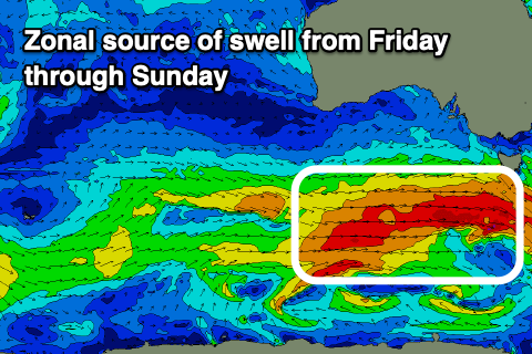
Moving into Friday and Saturday, a strengthening frontal progression moving in from the west should generate building levels of mid-period W/SW swell with the fetch strength now expected to reach gale-force though remain very zonal and west in nature.
This should kick up moderate levels of W/SW swell through Friday, building rapidly towards 3ft+ into the afternoon, then easing slowly Saturday from the 3ft range.
The elongated nature of the progression will result in a slow easing trend with Sunday still coming in 2-3ft on the sets.
Looking at the local winds and a trough associated with the swell generating front will bring moderate W/SW tending S/SW then S/SE winds on Friday with a good chance of early W/NW winds across Clifton.
Saturday is the pick with a N/NW offshore before a trough brings a shallow S/SE change into the afternoon with similar winds due Sunday.
The outlook for early next week remains favourable with a strengthening polar frontal progression expected to bring gale to severe-gale W/NW winds through our south-western swell window on the weekend, generating some reinforcing swell for Tuesday.
This looks to be 2ft+ and possibly a little undersized at dawn with light morning offshore winds. After this though the period looks slower, but more on this Friday.