Fun week ahead

Southern Tasmanian forecast by Craig Brokensha (issued Monday April 7th)
Best Days: Tomorrow, Wednesday, Thursday, dawn Friday, Saturday morning
Features of the Forecast (tl;dr)
- Moderate + sized SW swell this afternoon, easing tomorrow with N/NW tending variable winds ahead of late sea breezes
- Smaller Wed with N/NW tending variable NE winds
- Small-mod sized SW swell Thu with N/NW-N winds
- Easing SW swell Fri AM, with a new moderate sized W/SW swell building through the day, peaking Sat
- Early NW tending W/SW-SW winds Fri
- N winds Sat AM ahead of a midday S change
- Smaller Sun with lingering S winds
Recap
The surf was small and clean on Saturday with waves in the 2ft range across Clifton, while yesterday our new W/SW groundswell started filling in with clean sets to 3ft through the morning, building to an easy 4ft through the day as winds shifted more W/NW.
This morning the swell was still 3-4ft but on the ease with early offshores that shifted onshore through the morning.
This week and weekend (Apr 8 - 13)
The coming week looks fun with plenty of reinforcing swells due under favourable winds.
The large, windy stuff from the weekend is on the decline and a reinforcing mid-period SW swell for today, generated by a strong polar front projecting up and over us today should produce 4ft+ sets into this afternoon before easing from the 3ft to possibly 4ft range tomorrow morning.
Local conditions look great with a N/NW offshore, tending variable ahead of late sea breezes.
Wednesday will be smaller though likely still 2ft+ and with N/NW tending variable NE winds.
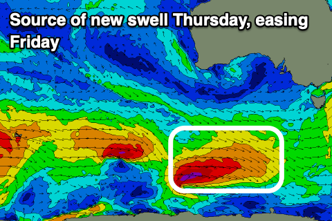
Into Thursday, a good reinforcing SW groundswell is due, produced by a small, tight polar low pushing along the polar shelf over the coming days. A good fetch of gale to severe-gale W’ly winds should produce a spike back to 2-3ft across Clifton under all day offshore N/NW-N winds.
A trough looks to bring a W/SW-SW change during the mid-morning on Friday and ahead of it, conditions will be clean with waves in the 2ft range.
Into the afternoon and Saturday morning, a good W/SW is due, produced by a healthy Southern Ocean frontal progression moving in and under the country later week.
It will be zonal but fetches of strong to gale-force W’ly winds should generate a moderate sized mid-period swell for Friday afternoon to 2-3ft with 3ft sets holding Saturday morning.
Saturday morning will be the pick under a N’ly offshore before a trough brings a S’ly change during the middle of the day, with lingering S’ly winds a possibility Sunday as the swell eases. We’ll confirm this Wednesday though.
Longer term there’s plenty more fun swell due into early next week, but more on this Wednesday.