Very active period ahead

Southern Tasmanian forecast by Craig Brokensha (issued Friday April 4th)
Best Days: This afternoon, tomorrow, Sunday ahead of the change, Monday early, Tuesday, Wednesday
Features of the Forecast (tl;dr)
- Small-mod sized W/SW swell tomorrow with W/NW tending NW winds
- Moderate sized W/SW groundswell building Sun with freshening N/NW tending W/NW winds ahead of a late PM W/SW change
- Moderate + sized SW swell building Mon with gusty W/NW-W tending strong SW winds
- Easing swell Tue with N/NW tending variable winds
- Smaller Wed with NW tending N winds
Recap
Conditions were a little better than expected through yesterday morning with plenty of S/SE swell holding the 2ft range while today we’ve got weaker, smaller surf with nothing of any real power.
Some better groundswell is due into this afternoon as winds freshen from the NW with sets to 2ft expected.
This weekend and week (Apr 5 - 11)
This afternoon’s freshening NW winds will be ahead of a cold front, with it due to bring a fun increase in mid-period W/SW swell tomorrow, thanks to a fetch of strong W/SW winds being projected towards us.
This should boost Clifton to 2ft+ and pre-dawn W/SW winds are due to ease and shift W/NW through the morning and then more NW into the afternoon.
Of greater significance is the building W/SW swell through Sunday followed by some better aligned SW energy into early next week.
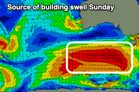
As touched on in Wednesday’s notes, a great, elongated fetch of gale to severe-gale W’ly winds will move in from the west through today, passing through our western swell window.
This isn’t ideal but the strength of the winds look great and with this we should see a moderate sized W/SW groundswell building through Sunday, reaching 3-4ft through the day across Clifton and with fresh N/NW tending W/NW winds ahead of a late afternoon W/SW change.
This change will be linked to a more favourably aligned but weaker, trailing polar front moving through, bringing with it some reinforcing SW swell for Monday that looks to reach 4-5ft into the afternoon under a gusty W-W/NW tending stronger SW breeze. The morning should be 4ft and best ahead of the change.
Tuesday onwards looks the pick though with a slow easing trend in SW energy as winds swing back to the N/NW along with easing 3-4ft sets, smaller Wednesday and dropping from 2-3ft with Thursday dropping back to 1-2ft.
Longer term, a significant polar frontal progression moving up towards the country from the Heard Island region early next week looks to generate a moderate to large W/SW groundswell for next weekend with what looks to be northerly winds. More on this Monday, have a great weekend!