Great run of surf ahead
Southern Tasmanian forecast by Craig Brokensha (issued Monday March 17th)
Best Days: Keen surfers Friday, beaches Saturday morning, keen surfers Tuesday and Wednesday mornings
Features of the Forecast (tl;dr)
- Easing SW swell tomorrow ahead of a new mid-period W/SW swell into the PM, peaking Wed AM
- Stronger SW groundswell building Wed PM, peaking, easing Thu
- N/NW tending variable winds tomorrow, N/NW tending variable then fresh E/NE winds later Wed
- Gusty N/NE tending N/NW then late W/SW winds Thu
- New W/SW swell Fri with N/NW tending E/NE winds
- Easing swell Sat with N/NW tending W/NW winds
- Moderate sized W/SW groundswell Sun with variable S winds ahead of sea breezes
Recap
Saturday offered tiny, clean waves while yesterday, a new increase in groundswell was met with early offshore winds before a strong change moved through associated with a cold front.
The swell from this frontal system has peaked today with strong 3ft surf under cross-offshore winds.
This week and weekend (Mar 18 - 23)
The current swell is expected to ease into tomorrow morning back to the 2ft+ range, but it will only be temporary with some new mid-period W/SW energy due into the afternoon, peaking Wednesday morning.
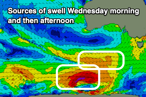
This will then be followed by some stronger SW groundswell into Wednesday afternoon, with the source of both these swells being the same polar low.
A good fetch of pre-frontal W/NW winds on the north-west flank of the low will generate the mid-period swell for tomorrow afternoon and Wednesday morning to 2-3ft while a fetch of severe-gale W’ly winds around the core of the low should produce the stronger groundswell for the afternoon to 3ft to occasionally 4ft, easing Thursday from 2-3ft.

Local winds look great tomorrow and N/NW tending variable, with N/NW tending variable then fresh E/NE winds on Wednesday.
Into Thursday, early strengthening N/NE winds will shift N/NW ahead of a late W/SW change.
The late change will be associated with a weakening polar frontal system projecting up and into us, generating a small increase in W/SW swell for Friday to 2ft or so across Clifton.
Morning offshores will give into E/NE sea breezes Friday with Saturday seeing N/NW tending W/NW winds, keeping conditions clean all day as the swell eases from 1-2ft.
Of greater importance is a better W/SW groundswell due into Sunday, with a strengthening low moving in from the west likely to generate a fetch of W/SW gales and 3ft of swell but with early S winds that will probably tend variable through the morning. This depends on the timing of a trough so check back here on Wednesday for a clearer idea on the wind outlook.

