Lots of wind changes this period

Southern Tasmanian forecast by Craig Brokensha (issued Friday February 14th)
Best Days: Monday morning, Wednesday morning, Friday morning
Features of the Forecast (tl;dr)
- Late increase in small W/SW swell later today and tomorrow AM, easing
- Building S/SW windswell tomorrow PM and new mid-period swell Sun
- Mod-fresh W/SW tending strong S/SW winds tomorrow, strong S/SW Sun
- Easing S/SW swell with a new S/SE swell Mon under N/NW winds ahead of weak sea breezes
- Strong SW-S/SW winds Tue with building levels of S/SW swell
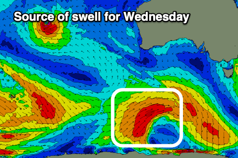
- New SW groundswell Wed with N/NW winds, tending strong W/SW-SW into the PM
- Easing swell Thu with W/SW-SW winds, smaller Fri with a morning NW breeze
Recap
A tiny wave was seen yesterday morning before the tide filled in, even smaller today.
This weekend and next week (Feb 15 - 21)
The weekend will be generally poor thanks to a polar front projecting up and into us, bringing W/SW tending strong S/SW winds tomorrow that will remain strong from the S/SW into Sunday.
Swell wise, an initial pulse of W/SW energy is due later today and tomorrow morning, generated by a south-east tracking low across us today. It’s only due to hit 1-2ft, while the size will ease before localised windswell kicks up later tomorrow, peaking Sunday to a junky 2-3ft.
As touched on in Wednesday’s notes, a small low is due to form south-east of us during Sunday, though it doesn’t look as favourable swell production wise as it was earlier in the week.
A quick stalling fetch of strong S’ly winds should produce a small S/SE swell for Monday to 2ft+, easing into Tuesday.
This looks like the best morning to surf (Monday) with light N/NW offshores due ahead of weak sea breezes.
The clean conditions won’t last long though with another trough due to move in just before dawn on Tuesday, bringing with it strong SW-S/SW winds and building levels of windswell and mid-period energy again into the afternoon.
It only looks 2ft or so, while more size is due into Wednesday/Thursday generated by a more substantial polar fetch of strong to at times gale-force W’ly winds from Sunday through next week.
This should provide better 2-3ft waves along with a N/NW offshore Wednesday morning, giving into a strong W/SW-SW change and then W/SW-SW winds Thursday. There’s an outside chance for early W/NW winds Thursday, but Friday looks more reliable with fun surf easing back from 2ft+ or so.
Longer term the outlook is slower, but more on this Monday. Have a great weekend!