Plenty of swell from the weekend but with plenty of wind

Southern Tasmanian forecast by Craig Brokensha (issued Wednesday February 12th)
Best Days: Saturday morning for the keen, Tuesday morning
Features of the Forecast (tl;dr)
- Late increase in W/SW swell Fri with NW tending SW winds
- Mix of swells building Sat PM (small early), peaking Sun
- W/NW tending strong SW winds Sat, strong SW-S/SW winds Sun
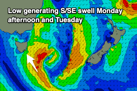
- Persistent S/SW winds Mon with a moderate sized S/SE swell for the PM, easing Tue
- W/NW winds Tue AM ahead of a late S/SW change
- Inconsistent W/SW groundswell Wed with W/SW tending S/SW winds
Recap
Our new swell came in nicely yesterday but conditions were a little mixed and not ideal with variable tending E’ly breezes, cleaner this morning but fading from 1.5ft.
This week and weekend (Feb 13 - 16)
The end of the week looks poor for surf with tiny surf due tomorrow, while on Friday, a late forming low drifting south-east through our swell window may kick up a late pulse of W/SW swell but with freshening onshore winds.
Behind this low, a more elongated polar front should project a fetch of strong SW winds up through our south-western swell window, generating a mix of windswell and mid-period energy for Saturday afternoon and more so Sunday morning.
Building surf to 3ft is expected but with W/NW tending strong SW winds on Saturday (small early and to 1-2ft) with Sunday seeing strong SW-S/SW winds all day.
Into Monday, strong SW-S/SW winds will persist thanks to the formation of a low south-east of us through Sunday, but this will produce some reinforcing S/SE swell for the afternoon, coming in at 3ft+ before easing Tuesday from 2-3ft.
Tuesday morning looks best for a surf as winds veer back W/NW temporarily ahead of another trough and S/SW change late morning.
Lingering W/SW tending SW winds on Wednesday may spoil a new, long-range W/SW groundswell, though the size has been downgraded a touch in any case.
This low, forming thanks to Tropical Cyclone Vince being absorbed into the westerly track, looks to form a little further west and north than ideal, with slow 2ft sets due across Clifton, fading Thursday.
Some new mid-period SW swell may take its place later week but more on this Friday.