Good swell for the weekend, ruined by onshore wind

Western Australian forecast by Craig Brokensha (issued Friday February 7th)
Best Days: Tuesday morning
Features of the Forecast (tl;dr)
- Inconsistent, moderate sized W/SW groundswell tomrorow AM, easing and smaller Sun
- Gusty S winds, tending S/SE late tomorrow, weaker E/SE on Sun, freshening
- E/SE tending fresh E/NE winds Mon
- Building SW swell later Mon, peaking Tue with N tending strong NE winds
- Swell fading Wed
Recap
Yesterday was clean with a good increase in swell to 2ft across Clifton before sea breezes kicked in, while this morning was small to tiny and clean early before a trough brought a strong onshore change, writing off the surf for the rest of the day.
This weekend and next week (Feb 8 - 14)
As touched on through the week, later today and more so tomorrow morning a strong new W/SW groundswell is due across the state, generated by a strong polar low that fired up to the south-west of Western Australia.
Unfortunately the associated onshore winds with the remnants of the system moving through today are still expected tomorrow morning with a fresh S’ly wind due through the morning, tending S/SE later in the day.
This will spoil the 2ft to occasionally 3ft sized swell that’s due to ease into the afternoon and back off further from 1-2ft on Sunday under lingering E/SE winds.
This isn’t great at all for the weekend warriors.
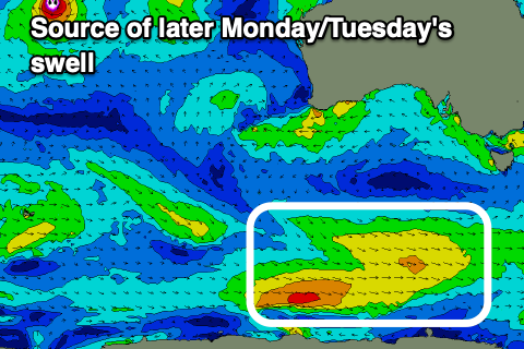
Monday will be tiny, while come Tuesday some new mid-period SW swell is due, generated by a weak but broad polar frontal system skirting the polar shelf.
Fetches of strong W’ly winds should kick up 1-2ft of swell later Monday but more so Tuesday and with E/SE tending E/NE winds on the former, N tending stronger NE on Tuesday as a broad trough sits over the state.
Try and make the most of this small swell as the rest of the week looks tiny with nothing of interest until possibly next weekend when some new swell is due. Have a great weekend!