Fun run of small surf
Southern Tasmanian Australian forecast by Craig Brokensha (issued Monday January 27th)
Best Days: Wednesday morning, Thursday morning, Friday morning, Sunday morning, early Monday
Features of the Forecast (tl;dr)
- Building W/SW-SW swell Tue with NW tending strong W/SW winds
- Peak in W/SW-SW swell Wed with W/NW tending S/SE winds
- Smaller Thu and Fri but not below 1-2ft
- Mix of tiny W/SW groundswell Sat AM and better W/SW swell for the PM, easing Sun
- W/NW winds ahead of sea breezes Sat, early N/NE Sun, tending S
- Possible stronger W/SW groundswell Mon with early variable tending S winds
Recap
Saturday started small and clean with 1-2ft surf while our stronger pulse of W/SW energy for yesterday came in at a good 2-3ft under morning offshores.
Today the swell has backed away quickly with less than ideal winds and slow 1ft to occasionally 2ft sets.
This week and weekend (Jan 28 - Feb 2)
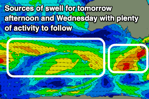
Tomorrow will start tiny, but into the afternoon and more so Wednesday a couple of strengthening fronts look to bring with it fetches of strong to gale-force W/SW winds directly south of us.

The first tomorrow morning should generate a pulse of mid-period SW swell to 2ft+ through the afternoon but with strong W/SW winds.
Wednesday morning should come in around 2ft+ again under a morning W/NW breeze before afternoon, S/SE winds kick in.
The swell looks to ease back from 1-2ft on Thursday with Friday coming in similar thanks to weak trailing frontal activity maintaining slow sets for the patient.
On Saturday a mix of inconsistent, tiny W/SW groundswell is due through the morning, produced by a small, tight low currently in the Heard Island region.

A secondary weak frontal system moving in behind this low, under the country should generate some better W/SW swell for the afternoon Saturday, easing Sunday.
We’re only looking at small 2ft sets at the peak Saturday afternoon and Sunday morning with light W/NW winds Saturday morning, giving into sea breezes and N/NE winds Sunday morning.
Longer term a strong low forming south of Western Australia, then drifting south more into our swell window could generate a fetch of W’ly gales and moderate sized W/SW groundswell for Monday week. Winds may be variable NE early ahead of a S’ly change but we’ll review this Wednesday.

