Average outlook persists
Southern Tasmanian Forecast by Craig Brokensha (issued Monday January 6th)
Best Days: Likely tomorrow morning (winds pending), Sunday morning
Features of the Forecast (tl;dr)
- Small SW swell tomorrow, easing with light-mod S/SW-SW winds (possibly variable at times) ahead of fresher PM winds
- Tiny for the rest of the week
- Small W/SW groundswell Sun with N/NE tending fresh S-S/SE winds mid-late AM
Recap
A small bump in swell Friday afternoon eased back to 2ft on Saturday morning with clean conditions. Yesterday was poor as a trough moved through and early this morning we saw light winds before strong S’ly winds kicked back in again.
This week and weekend (Jan 7 - 12)
The outlook is generally small to tiny thanks to the lack of any major swell generating systems moving through our swell window while winds look funky at times as well thanks to troughy weather moving in from the west.
Firstly, today’s trough should clear tomorrow but 1-2ft surf should still be breaking across Clifton (generated by the trough) though winds look to linger onshore, light to moderate out of the S/SW-SW.
There’s a chance for variable winds at times through the morning so keep an eye on the local wind observations/cams.

The rest of the week looks cleaner but tiny, while our next swell is due Sunday.
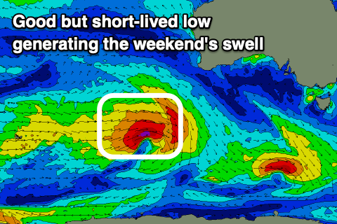
The source will be a strong low firing up to the south-west of Western Australia Wednesday, generating a short-lived fetch of gale to severe-gale W’ly winds while tracking slightly east-southeast.
This slight projection will be favourable for us with a small, inconsistent 2ft wave due Sunday under N/NE tending S-S/SE winds mid-late morning.
The morning window will be worth making the most of before things go quiet again next week. More on this Wednesday.

