Average period of small to tiny surf
Southern Tasmanian Forecast by Craig Brokensha (issued Friday December 20th)
Best Days: Sunday morning, Wednesday morning for beginners
Features of the Forecast (tl;dr)
- Building, small W/SW swell tomorrow, easing Sun AM
- Strengthening SW tending S/SW winds tomorrow, NW tending variable ahead of a late SW change Sun
- Small W/SW swell Mon/Tue, fading Wed
- Strong S/SW-SW winds Mon, fresh W/SW-SW Tuesday (possibly W/NW at dawn)
- N/NW winds Wed ahead of sea breezes
- Possible moderate sized W/SW swell next weekend
Recap
The surf has been mostly tiny with light winds yesterday morning and a touch of east in the wind today adding slight imperfections before the sea breeze kicked in.
This weekend and next week (Dec 21 - 27)
The coming period will consist of small W/SW swells, the first and least consistent for tomorrow afternoon and Sunday being superseded by some better energy Monday/Tuesday.
A weak, zonal frontal progression moving under the country this week generated tomorrow afternoon and Sunday morning’s energy, with slow 1ft to occasionally 2ft sets due but with strong onshore winds tomorrow, cleaner Sunday under a N/NW offshore before varying into the afternoon ahead of a late, strong SW change.
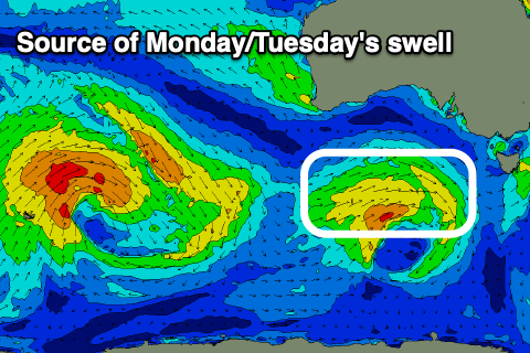
This change will be linked to the better swell producer for early next week, with a slow moving low and fetch of sub-gale-force W/SW winds due to generate 1-2ft of swell for Monday/Tuesday.
Winds on Monday look to be poor and strong from the SW-S/SW in the wake of Sunday evening’s change, with Tuesday also coming in dicey. We may see early W/NW winds but otherwise W/SW breezes are due and we’ll have to review this next Monday

Wednesday (Christmas Day) looks cleaner under a N/NW offshore but tiny as the swell fades from 1-1.5ft.
The end of the week unfortunately remains tiny, but next weekend provides more hope as a deepening mid-latitude low moves across the state, bringing strong to gale-force winds through our western and southern swell windows.
The exact make up of the low, size and timing of the swell look up in the air still and winds will be out of the west, so check back here on Monday for the latest on this. Have a great weekend!

