Tiny week of surf with less than ideal winds
Southern Tasmanian Forecast by Craig Brokensha (issued Monday December 16th)
Best Days: No good days but try Thursday morning
Features of the Forecast (tl;dr)
- Tiny W/SW groundswell Wed with a localised swell into the PM, easing Thu
- W/NW tending strong S winds Wed, variable S Thu AM, then freshening
- Tiny W/SW swell Sat with a SW change mid-AM, N tending SE Sun
Recap
Every morning over the weekend provided fun surf with 2ft waves on Saturday morning, backing off to 1-2ft yesterday owing to some fun mid-period swell filling in.
Today the surf was tiny and wind affected.
This week and weekend (Dec 17 - 22)
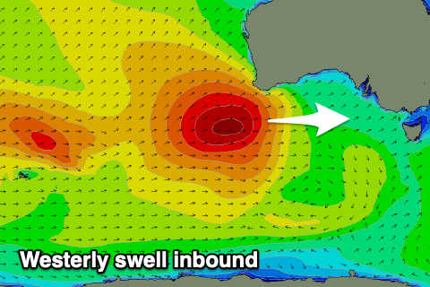
As touched on last week, we’ve got a tiny outlook ahead thanks to the storm track sitting too far north of us and being aimed mostly towards Western Australia.

Tomorrow will be tiny while a very west groundswell is due on Wednesday, generated by a strong low that formed south-west of Western Australia. The swell generating fetch was too far north of our swell window with the size not expected to top 1ft+.
The remnants of the swell generating system will move through Wednesday bringing a strong S change and some weak 1-2ft swell into the afternoon. The morning will be cleaner but tiny.
The swell will fade Thursday likely from 1-2ft and lingering S’ly winds might make for lumpy conditions ahead of sea breezes.
Come the weekend, another tiny W/SW swell is due, generated by a strong but distant and again, unfavourably positioned low moving in from the Heard Island region.
Infrequent 1ft+ sets are likely Saturday, fading Sunday. A trough will bring an onshore change shortly after dawn Saturday with cleaner conditions Sunday for beginners.
Longer term a slightly better W/SW swell is likely mid-next week, but more on this Wednesday.

