Fun surf days ahead
Southern Tasmanian Forecast by Craig Brokensha (issued Wednesday November 20th)
Best Days: Tomorrow morning, Friday morning, Saturday morning
Features of the Forecast (tl;dr)
- Moderate sized SW groundswell tomorrow, possibly under sized at dawn with N-N/NE tending gusty S/SE-SE winds
- Easing swell Fri with N winds ahead of sea breezes
- Moderate sized S/SW groundswell Sat AM, easing with N/NE-N winds ahead of a late S change
- Lingering S winds Sun with easing surf
- Dicey winds Mon/Tue with a period of W/NW breezes likely Tue AM
Recap
A fun 2ft wave pushed into Clifton yesterday with favourable winds through the morning ahead of fresh sea breezes, similar today with a little less swell.
This week and weekend (Nov 21 - Dec 1)
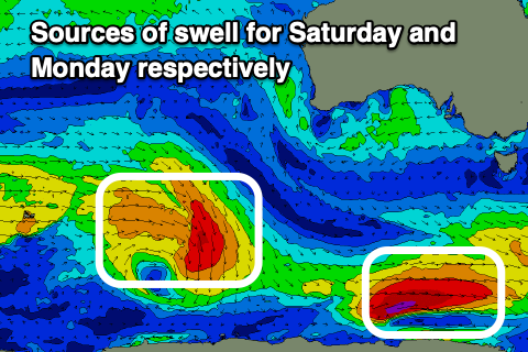
As Ben pointed out on Monday, a good pulse of SW groundswell is due tomorrow, generated by a strong polar low that fired up south-west of Western Australia. This should provide inconsistent but good 3ft sets through the day, with it possibly being a little undersized early.
Winds will have a bit of north in them, coming from the N-N/NE during the morning ahead of fresh S/SE-SE sea breezes.
The swell will ease through Friday under a light morning offshore before sea breezes kick in again.

Now come Saturday, a deepening low drifting in from the south-east over the coming days should generate a good pulse of S/SW groundswell, with it deepening in our southern swell window tomorrow.
The fetch is thin but strong and we should see a good pulse of swell to 3ft during the morning, easing off through the day and then smaller Sunday.
N-N/NE winds will persist most of the day Saturday ahead of a late onshore change thanks to a trough, while Sunday looks to see lingering S’ly winds in the wake of the trough.
Moving into next week and early the surf looks relatively small and with dicey winds thanks to troughy weather, with Tuesday morning likely coming in cleanest. A strong new W/SW groundswell is due later in the week, but more on this Friday.

