Strong spike of swell Wednesday, smaller and more S later week
Southern Tasmanian Forecast by Craig Brokensha (issued Monday October 21st)
Best Days: Wednesday morning, Thursday morning, Saturday morning
Features of the Forecast (tl;dr)
- Tiny W/SW swell tomorrow with strong N/NE tending S/SW winds
- Spike of SW groundswell Wed with variable N-N/NE tending S/SE winds ahead of a late NW change
- Easing SW swell Thu with strong W/NW tending W/SW-SW winds
- Small S swell Fri with W/SW-SW winds
- Easing S swell Sat with N/NW tending SE winds
Recap
It was a poor weekend of surf all round with onshore winds Saturday and tiny, lumpy surf yesterday.
Today our tiny W/SW swell has come in at 1-1.5ft with clean conditions this morning ahead of fresh sea breezes.
This week and weekend (Oct 22 - 27)
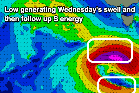
As touched on in last week’s updates, we’ve got a dynamic couple of days ahead as a strong low forms south-west of us tomorrow, generating a tight fetch of severe-gale to storm-force W-W/NW winds.
While not ideally aimed through our swell window, this should generate a good spike of SW groundswell for Wednesday to 3-4ft across Clifton, much better than the models are forecasting.
The spike will be short lived, with it easing back through Thursday from 2ft or so.

We should also then see a small S’ly pulse on Friday to a similar 2ft generated by polar S’ly winds at the base of the low.
Looking at the local winds and variable N-N/NE winds are due on Wednesday morning ahead of weak S/SE sea breezes, strong W/NW tending W/SW-SW on Thursday as a frontal system moves through.
Friday then looks dicey with lingering W/SW-SW winds but we’ll confirm this on Wednesday.
Into the weekend, and we’ve got easing levels of S’ly swell from 1-2ft Saturday with cleaner conditions, tiny Sunday.
The longer term outlook remains slow early next week with tiny levels of W’ly swell and tricky winds. More on this Wednesday.

