Sizey tomorrow, cleanest Sunday
Southern Tasmanian Australian Forecast by Craig Brokensha (issued Friday October 11th)
Best Days: Protected spots tomorrow, Sunday until the change hits, Tuesday morning
Features of the Forecast (tl;dr)
- Late increase in W/SW and SW swells Fri, peaking Sat with mod-fresh W/SW-W tending S winds
- Easing swell Sun with N tending S winds later PM
- Moderate sized S/SW groundswell building late Mon with strong S winds, easing Tue AM with modf-fresh N/NE tending stronger NE winds
Recap
Yesterday started tiny, while a cold front into the afternoon brought with it a small increase in localised swell which has come in at 1-2ft today. We’ve got more energy for the weekend so read on.
This weekend and next week (Oct 12 - 18)
A healthy frontal progression that started in the Southern Ocean, south-west of Western Australia is now moving in and under us today with it due to bring a good W/SW groundswell mixed with local mid-period SW energy tomorrow from trailing SW fetches today.
The surf looks to mostly come in at 3ft with possibly the odd bigger one in the morning, easing through the day and then down from 2ft tomorrow morning.
Winds tomorrow look a little dicey and moderate to fresh from the W-W/SW, shifting S’th through the day, with Sunday coming in much cleaner under a fresher N’ly offshore, easing and tending S’ly late.

This late change will be associated with a trough moving in from the west, with it bringing stronger S’ly winds on Monday as it forms into a low to our north-east.
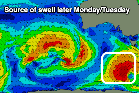
This will spoil a good S/SW groundswell that’s due to arrive later in the day. The source will be a strong polar low forming south-west of us on Sunday and this kick up building surf to 3-4ft on dark, easing from a similar size on Tuesday.
Winds should rapidly ease and swing back to the N/NE on Tuesday morning, creating cleaner conditions before stronger NE winds kick up into the afternoon.
Longer term the outlook is a bit slower thanks to the westerly storm track sitting further north than it is currently. More on this Monday. Have a great weekend!

