Generally tiny to flat weekend
Southern Tasmanian Forecast by Craig Brokensha (issued Friday October 4th)
Best Days: Later Sunday for the desperate, Wednesday morning
Features of the Forecast (tl;dr)
- Small E/SE swell for the coming days with N/NW tending SW winds tomorrow, N tending W/NW Sun
- Small to tiny W/SW swell later Sun and Mon AM
- Moderate sized mid-period S/SW swell building later Mon, peaking Tue AM
- SW winds generally, likely lighter and W early Tue
- NW tending SE winds Wed
- Moderate sized W/SW swell from later next week
Recap
Clean, fun 2ft waves yesterday morning ahead of strong easterly winds into the afternoon, tiny this morning and clean again.
This weekend and next week (Oct 5 - 11)
The coming days look tiny, with the East Coast offering better waves as an E/SE groundswell fills in.
Locations down the South Arm exposed to this energy should also see surf, with winds out of the N/NW tending SW tomorrow, then N tending W/NW on Sunday.

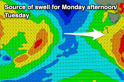
Into Sunday afternoon and Monday morning, a tiny hint of W’ly swell is due from a northward positioned frontal system moving in over the coming days. It doesn’t look to generate much over 1.5ft, while the remnants of one of these systems will intensify south of us Monday, generating some weak S/SW swell for the afternoon and Tuesday.
As expected this went the way of the EC forecast model, with it being much weaker and we’re only due to see 2-3ft of swell later Monday but more so Tuesday morning (3ft) and with gusty SW winds, that may tend lighter W’ly for a shore period early Tuesday.
Wednesday looks cleaner with a NW offshore and easing 2ft+ of S/SW swell.
Longer term, the outlook from Friday is active with a series of healthy frontal systems due to move in from the west, bringing plenty of swell and west winds. More on this Monday. Have a great weekend!

