New swell for the coming two days then slow
Southern Tasmanian Forecast by Craig Brokensha (issued Monday September 30th)
Best Days: Early tomorrow, Wednesday morning, Thursday morning
Features of the Forecast (tl;dr)
- Moderate sized W/SW swell building tomorrow, peaking later, easing Wed AM from a similar size
- Early N/NW winds tomorrow, tending gusty W/SW-SW mid-late AM
- NW tending fresh S/SE winds Wed
- Light N tending strong E/NE winds Thu
Recap
The weekend was small and clean to the 1-2ft range for the most part, tiny today and to 1ft.
This week and weekend (Oct 1 - 6)
The coming days are the best of the period, with nothing much due to end off the week or into the weekend.

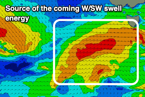
We’re currently seeing a healthy mid-latitude frontal system moving in from the west, generating fetches of strong to at times gale-force W-W/NW winds.
The progression as whole will move across and under us tomorrow, shifting winds W/SW with building levels of mid-period W/SW swell due to be followed by a peak in energy on later in the day/early Wednesday.
Clifton should build build tomorrow from 1-2ft to 3ft and ease from a similar size on Wednesday with Thursday fading from 1-2ft.
Winds will be favourable early tomorrow and N/NW ahead of the swell, shifting W/SW mid-late morning as the swell generating front moves through.
Wednesday morning will be clean again ahead of fresh S/SE sea breezes, then N tending strong E/NE on Thursday.
The surf will fade and bottom out Friday/Saturday/Sunday, with the next swell generating front due to move through Monday.
This looks to be a better positioned polar system but we’ll have a look at this again on Wednesday.

