Mixed period with plenty of swell still to come
Southern Tasmanian Forecast by Craig Brokensha (issued Monday September 23rd)
Best Days: Tomorrow, Wednesday morning, Friday morning, Saturday and Sunday mornings
Features of the Forecast (tl;dr)
- Moderate sized mix of easing W/SW groundswell, W groundswell and new mid-period SW swell
- Moderate N-N/NW tending fresher N/NE winds
- New, moderate sized SW swell building rapidly Wed with W/NW tending fresh W/SW-SW winds
- New moderate sized S/SW swell Thu with strong W/SW tending SW winds
- Easing surf Fri with N/NW tending E winds
- Small weekend with N/NW tending SE winds Sat, stronger N/NE winds Sun, easing into the PM
Recap
Friday’s strong pulse of SW groundswell held well into Saturday morning with clean conditions and straight 3-4ft sets, smaller and back to a fun 2ft+ yesterday.
Today we’ve seen a large W/SW groundswell fill in with Clifton building from 3-4ft to 4-5ft this afternoon but with choppy conditions developing under a strong W/SW breeze.
This week and weekend (Sep 24 - 29)
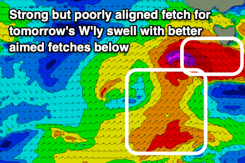
Following today’s large W/SW groundswell we were expected to see a secondary pulse of more westerly angled groundswell for tomorrow morning, but unfortunately the frontal system linked to this has come in weaker and stayed a little too far north than ideal.
We instead are seeing severe-gale W/NW winds moving through our western swell window and this isn’t likely to add too much more energy to the easing W/SW groundswell that’s in the water now.
Behind the front which has already moved through this morning was a fetch of SW gales but moving quickly through our swell window. This will produce a small mid-period pulse through tomorrow but below the groundswell energy.
So all in all it looks like we’ll be seeing easing surf from the 3ft+ range but with light to moderate N-N/NW tending fresher N/NE winds.

Into Wednesday, a spike of close-range SW swell is due, with a tight, deepening low due to generate a fetch of severe-gale to storm-force SW winds directly south-west of us early morning.
This should kick up a quick spike to 3-4ft but early W/NW winds will shift W/SW-SW and strengthen through the day.
This swell will ease rapidly Thursday, but another polar front projecting up and into us during Wednesday should generate some mid-period S/SW swell to 3-4ft through the day though with strong W/SW tending SW winds.
Friday looks best with clean easing surf from 2-3ft under a N/NE tending E’ly breeze.
Longer term, the weekend and early next week look on the small side but with persistent surf to 2ft or so. More on this Wednesday.

