Very active period ahead
Southern Tasmanian Forecast by Craig Brokensha (issued Monday September 16th)
Best Days: All period selected spots
Features of the Forecast (tl;dr)
- Moderate sized mix of swells tomorrow with N/NW-NW tending W/NW winds and strengthening
- New moderate sized W/SW swell Wed AM, easing later with N/NW tending W/NW winds
- Smaller Thu AM with strengthening N/NW winds
- Mod-large W/SW groundswell Fri with strong NW winds, tending N/NW later
- Easing swell Sat with N/NW winds
- Moderate sized W/SW groundswell building later Sun with strong W/NW tending NW winds
Recap
Poor conditions on Saturday with plenty of size, cleaning up through protected spots yesterday with a drop in energy back to 2-3ft.
Today there was a window of OK conditions but a cold front has since moved through bringing with it an increase in swell to the 4ft range. A mix of close-range energy and SW groundswell are breaking.
This week and weekend (Sep 17 - 22)
We’ve got a very active period of surf ahead as a strengthening Southern Ocean frontal progression fires up thanks to a strengthening node of the Long Wave Trough across us.
Firstly, today’s mix of building swells are due to ease back through tomorrow as conditions clean up across the South Arm.
Easing 3ft+ sets are due across Clifton as winds shift N/NW-NW during the morning, tending W/NW into the afternoon while strengthening.
Into Wednesday, some new close-range W/SW swell is due to be in the water, generated by a slow moving frontal system moving in from the west, generating strong to near gale-force W-W/NW winds.
The swell should come in at 3ft through the morning with N/NW winds, easing later as winds tend W/NW. A further drop in swell is due on Thursday with strengthening N/NW winds, shifting strong W’ly mid-late afternoon as the next swell generating front moves through.
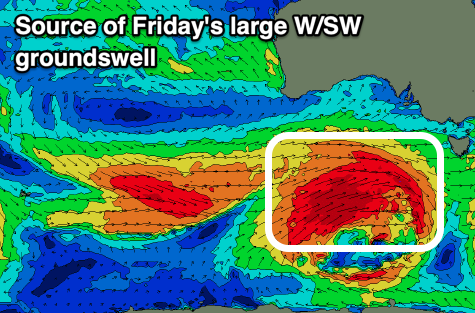
Now, this one will be quite a significant one, with a polar low moving in under the country tomorrow due to deepen, directing fetches of gale to severe-gale W/SW winds up through our western swell window before crossing us Thursday afternoon/evening.

A moderate to large sized W/SW groundswell is due from this source, peaking Friday to 4-5ft+ across Clifton along with fresh to strong NW winds, tending N/NW later.
Saturday looks clean as well with N/NW offshores as the W/SW groundswell eases, mixed in with smaller levels of reinforcing mid-period swell.
Easing 3-4ft sets are generally expected with Sunday coming in smaller ahead of the next increase in what looks to be more westerly aligned swell.
Back to back storms look to generate severe-gale to possibly storm force fetches generate moderate sized swell pulses for later Sunday/Monday and then Tuesday but check back here on Wednesday for more details.

