Tricky winds for the weekend, improving from Tuesday
Southern Tasmanian Forecast by Craig Brokensha (issued Friday September 13th)
Best Days: This afternoon if winds hold, later Sunday, Tuesday
Features of the Forecast (tl;dr)
- Moderate sized W/SW groundswell building this afternoon, peaking tomorrow AM, easing
- Strong W/SW to SW tending S/SW winds tomorrow
- W-W/SW winds Sun, strengthening and tending W/NW later
- Moderate sized SW groundswell Mon, peaking into the PM with strong SW winds
- Easing surf Tue with fresh NW tending W/NW winds
- Building W/SW swell energy mid-late week
Recap
Yesterday was clean and to 1-2ft, easing through the day while this morning is back to 1-1.5ft. Early variable winds and funky conditions have since cleaned up. A new W/SW swell is due this afternoon with winds expected to go more W/SW but we’ll wait and see.
This weekend and next week (Sep 14 - 20)
This afternoon’s building W/SW swell energy is due to peak tomorrow morning, generated by a great multi-fetched low moving in from the west the last couple of days.
A peak to 3-4ft is due across Clifton tomorrow morning, easing through the day and then down from 2-3ft on Sunday.
Winds tomorrow aren’t ideal and look to be strong from the W/SW tending SW and then S/SW, with Sunday looking a touch cleaner thanks to morning W-W/SW winds. These winds are due to tip W/NW later but the morning looks wind affected.
Looking at Monday, and a good new SW groundswell is due, generated by a polar fetch of gale to severe-gale W/NW-NW winds today and tomorrow.
This swell looks to peak through the afternoon to 3-4ft but with unfavourable, strong SW winds thanks to a secondary swell generating front moving through.
Tuesday will be cleaner but smaller with easing 2-3ft waves under a fresh NW tending W/NW breeze.

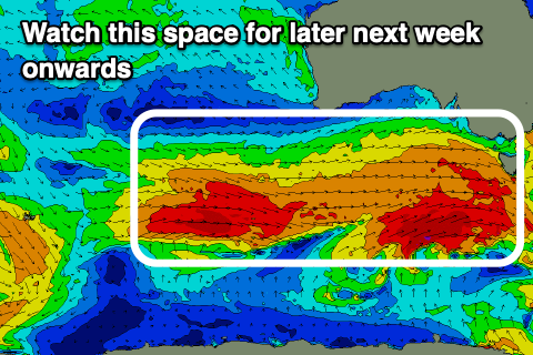
Of greater significance is the start of a great looking Southern Ocean frontal progression firing up under the country mid next week.
The strength and make up of each front is still yet to be settled, but we’re due to see back to back to back fetches of gale to severe-gale W/SW winds firing up towards us, generating moderate to large pulses of W/SW groundswell from Thursday through next weekend and early the following week.
Winds look favourable and generally out of the north-western quadrant but check back Monday for a clearer idea. Have a great weekend!

