Increasing activity from Friday through next week
Southern Tasmanian Forecast by Craig Brokensha (issued Wednesday September 11th)
Best Days: Tomorrow morning, Sunday morning, protected spots Monday, Tuesday
Features of the Forecast (tl;dr)
- Easing W/SW swell tomorrow with fresh N/NW tending W/SW-W winds
- Moderate sized W/SW groundswell building Fri PM, peaking Sat AM, easing
- Early W/NW tending SW winds Fri, strong SW tending S/SW Sat
- W/NW tending SW winds Sun with easing surf
- Moderate sized SW groundswell Mon with some localised W/SW swell with gusty W-W/SW winds
- Easing surf Tue with NW winds
Recap
Monday’s swell eased back through yesterday with sets to 2ft in the morning, slowing through the afternoon. This morning was still 1-2ft with a bit of rain and winds are now more east with lumpy, unappealing conditions.
This week and next (Sep 12 - 20)
A small pulse of new W/SW swell due this afternoon from a frontal system moving through early week is due to ease back tomorrow from a clean 1-2ft under a fresh NW tending W/SW-W breeze. The morning will be best.

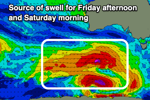
Into Friday afternoon and more so Saturday morning, we’ve got our good W/SW groundswell on the way, with a slight upgrade in the expected size.
The source is a broad, strong but slightly disjointed low moving in from the south-west of Western Australia, with prefrontal gale to severe-gale NW tending W/NW winds due to then be followed by gale to severe-gale W’ly winds, moving more into our south-western swell window while weakening tomorrow.
There’ll also be storm-force W/NW winds at the base of the low, though very small in scope.
All this activity should see a moderate sized W/SW groundswell generated, building strongly Friday afternoon to 3ft+, peaking Saturday morning to 3-4ft before easing into the afternoon, smaller Sunday but still 2-3ft in the morning.

Winds on Friday will shift from a dawn W/NW breeze to the SW with Saturday seeing strong SW tending S/SW winds in the wake of the swell generating front, likely tending back W/NW on Sunday morning.
Now, moving into next week we’ve got a mix of good new SW groundswell Monday from a great polar fetch of W/NW gales, followed by some localised W/SW swell from a secondary front passing under us.
The models look like they’re incorrectly combining the swells and over-forecasting the size but at this stage it looks to come in around 4ft but with W-W/SW winds, easing Tuesday with NW winds.
Longer term it looks like the Southern Ocean will fire up later week, but more on this Friday.

