Small west pulses continue
Southern Tasmanian Forecast by Craig Brokensha (issued Wednesday September 4th)
Best Days: Tomorrow morning, Saturday morning, Tuesday
Features of the Forecast (tl;dr)
- Easing W/SW swell tomrrow, tiny Fri
- Fresh N/NW tending NW winds tomorrow, strengthening N tending N/NW on Fri
- Small W/SW swell Sat AM with W/NW tending N/NW winds
- Tiny Sun AM
- Small, inconsistent W/SW swell energy for late Sun through Wed with winds from the N/NW-NW
- Stronger close-range W/SW swell Tue
Recap
Our strong pulse of W/SW swell came in on cue yesterday with lumpy 3-4ft waves in the morning, cleaning up into the afternoon.
Today was smaller but nice and clean with easing 2ft+ sets.
This week and next (Sep 5 - 13)
The current swell is due to ease further tomorrow, with slow 1-2ft sets due across Clifton, smaller into the afternoon.
Friday looks similar with incoming westerly energy being generated too far north of our swell window, with slow 1-1.5ft sets due across Clifton.
Local winds look great with a fresh N/NW tending NW breeze tomorrow, strengthening N tending N/NW on Friday.

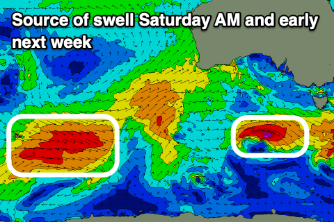
A slight bump in swell is likely Saturday morning to 1-2ft, generated by a very small, tight low drifting in from the west today and tomorrow. This swell will fade through the day as winds shift from W/NW to N/NW during the day.
A low point in swell is likely Sunday to the 1ft range, with some inconsistent, small W/SW energy due from later in the day through Monday to Wednesday next week.
A healthy but distant and slightly too far north progression of fronts to the south-west of WA will traverse east over the coming days, onwards to us early next week.
Pulses of 1-2ft W/SW swell are due later Sunday through Wednesday with a slightly stronger pulse of close-range swell for Tuesday to 2ft+.
Winds look generally out of the north-western quadrant, but we’ll review this Friday.

