Strong swell for Sunday and early next week
Southern Tasmanian Forecast by Craig Brokensha (issued Friday August 30th)
Best Days: Later tomorrow, Sunday, Monday morning, Tuesday, Wednesday, Thursday
Features of the Forecast (tl;dr)
- Building W/SW swell later tomorrow with strong W/NW tending N/NW winds, peaking Sun AM with strong N/NW winds
- Moderate sized reinforcing W/SW swell building Mon PM with strong W/NW tending W/SW winds, easing Tue with fresh W/NW-NW winds
- Moderate sized, inconsistent W/SW groundswell for later Wed, peaking Thu with N/NW winds
Recap
Our stronger pulse of W/SW swell filled in yesterday with clean conditions and pulsing 3-4ft sets most of the day, easing back today to the 2ft range with stronger offshore winds.
This weekend and next week (Aug 31 - Sep 6)
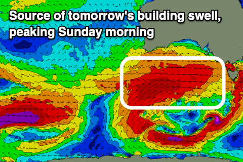
We’ve got building W/SW swell for the weekend thanks to a significant frontal progression moving in from under the country.
Fetches of severe-gale W/SW winds should generate building surf later tomorrow, peaking Sunday along with some additional localised W swell from a secondary severe front moving through the evening.

Building sets to 2-3ft are likely late tomorrow with Sunday coming in at 3-4ft. There’s the chance for the odd bigger one but these will be infrequent.
Winds tomorrow will be strong from the W/NW, shifting N/NW later with Sunday seeing strong N/NW winds all day.
As the swell starts to ease through Monday, a final frontal system will push up and across us, bringing a renewal of close-range energy to 3-4ft through the afternoon again, easing from a similar size Monday.
Winds will shift from W/NW to W/SW with this front Monday, with Tuesday seeing fresh W/NW-NW winds holding all day.
Trailing frontal activity moving in from the Indian Ocean looks to maintain 2-3ft of swell into late Wednesday/Thursday but we’ll have a closer look at this Monday. Have a great weekend!

