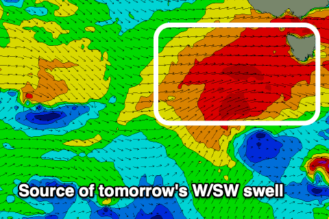
Strong west swells inbound
Southern Tasmanian Forecast by Craig Brokensha (issued Wednesday August 28th)
Best Days: This afternoon, tomorrow, Friday, Saturday, Sunday, Tuesday, Wednesday
Features of the Forecast (tl;dr)
- Moderate + sized W/SW groundswell tomorrow morning, easing later and smaller Fri
- Strong W/NW winds tomorrow, easing later and tending more NW, strong NW Fri (N/NW-W/NW early)
- Building W/SW swell later Sat with strong NW tending N/NW winds, peaking Sun AM with strong NW winds
- W/SW-SW winds Mon with smaller surf
- New W/SW swell Tue with strong W/NW winds
Recap
Tiny to flat conditions yesterday have given way to a fresh pulse of W/SW swell today to 2-3ft with clean conditions.

A few straight, solid sets in the mix still this afternoon
This week and next (Aug 29 - Sep 6)
Today’s swell will be superceded by a stronger increase in W/SW energy as a vigorous frontal progression moving in from the west generates a fetch of gale to severe-gale W/SW winds in our swell window this evening.

This should kick up 4ft of swell for tomorrow morning, easing later and then down from 2ft or so on Friday.
Conditions tomorrow will be best in protected spots with strong W/NW winds, easing later and tending more NW, with strong NW winds Friday, shifting between N/NW to W/NW early.
Moving into the weekend, a broad, southern ocean gyre with multiple frontal systems spinning around it from Friday through Saturday and Sunday should generate multiple pulses of moderate sized W/SW groundswell.
The first frontal system looks the strongest and most significant, with a fetch of severe-gale winds with embedded storm-force bursts due to project through our western swell window through Friday and then across us Saturday.
A large, long-period W/SW groundswell is due from this front, building through Saturday, peaking Sunday morning.
It looks to come in around 3-4ft Sunday morning, easing a little into the afternoon.

Strong NW tending late N/NW winds are due on Saturday as the swell builds towards 3ft, with Sunday seeing strong NW winds persisting all day.
Unfortunately a SW change with a passing front is due on Monday, with some reinforcing, tricky W/SW swell due Tuesday to 3ft+ or so under W/NW winds.
Longer term the end of the week looks to offer smaller levels of westerly swell but more on this Friday.

