Strong pulses of west swell due
Southern Tasmanian Forecast by Craig Brokensha (issued Monday August 26th)
Best Days: Wednesday onwards
Features of the Forecast (tl;dr)
- Tiny tomorrow
- Small to moderate sized pulse of W/SW swell Wed AM with strengthening N/NW tending W/NW winds
- Close range, moderate sized W/SW swell for Thu with W/NW winds
- Easing swell Fri with easing N/NW tending W/NW winds
- Moderate + sized pulse of W/SW swell for later Saturday/Sunday and Monday with W/NW-NW winds
- Larger surf likely early next week
Recap
Friday’s fun pulse of swell backed off into Saturday with variable winds creating clean conditions with easing 1-2ft sets. An onshore change due thanks to a trough stalled with no real wind seen all day.
Sunday was a little slower but still 1-2ft and nice and clean most of the day, tiny today.
This week and weekend (Aug 27 - Sep 1)
Better late than never!
We’re finally looking at an outlook that’s generally expected through the middle of winter, with all the strong activity that’s been primarily focussed in the Indian Ocean moving east, more towards the south-east of the country.
With this we’re set to see multiple, significant swell generating systems firing up through our western swell windows, generating still, tricky pulses of westerly energy.
Tomorrow will remain tiny, but very late in the day and more so Wednesday morning, our first pulse of W’ly energy is due.
This will be generated by a severe front dropping east-southeast into our swell window, with fetches of severe-gale W/NW-NW winds not being ideally aimed through our swell window at all.
In saying this, we should see some energy spreading out radially from this source, peaking Wednesday morning to 2ft to possibly 3ft, then easing through the day with strengthening N/NW tending W/NW winds.
We should then see a secondary, high riding frontal system moving through during the day Wednesday, producing a close-range W’ly swell for Thursday to 3ft to possibly 4ft with persistent W/NW winds.

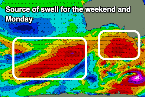
Friday looks smaller but clean with strong, easing N/NW tending W/NW winds, while as we move into the weekend, we’ve got a series of strong W/SW groundswells due.
The models still diverge a touch regarding the timing and sizes but we’re looking at back to back frontal systems generating fetches of gale to severe-gale W/SW winds under the country with the swells likely to come in around 3-4ft from later Saturday through Monday.
On the backside of the weekend’s activity, some stronger, more southerly positioned fetches look to generate larger surf early next week, but more on this Wednesday.

