Fading surf ahead of a west pulse Friday
Southern Tasmanian Forecast by Craig Brokensha (issued Wednesday August 21st)
Best Days: Today, Friday, early Saturday
Features of the Forecast (tl;dr)
- Tiny fading S swell tomorrow with a tiny background S/SE swell in the mix
- New moderate sized W swell Fri AM, easing later and further Sat
- N tending variable winds Fri, early N tending fresh E/NE Sat
Recap
Our good pulse of S’ly swell provided 3ft sets across Clifton yesterday morning, easing a little into the afternoon and then back from the 2ft range this morning. This afternoon the swell has slowed further and is on the way out.
This week and weekend (Aug 22 - 25)
The coming period remains slow with the current S’ly swell which is easing across the region due to become tiny tomorrow, mixed in with some tiny background S/SE energy. Don’t expect much over 1ft.
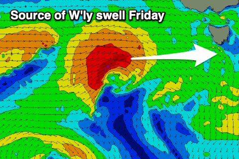
Into Friday, a tricky pulse of W’ly swell is due, generated by a tight but favourably tracking low that’s formed under Western Australia.
It started out of our swell window but we are now seeing it just moving into it, with a tight fetch of gale to severe-gale W’ly winds moving further south in latitude today.

The low will continue drifting south-east away from our swell window and with this so does the swell generating potential.
We should see a moderate sized pulse of energy from today’s fetch, with 2ft+ sets across Clifton Friday morning, easing into the afternoon and then fading from 1ft to possibly 2ft Saturday morning.
Winds look good on Friday and light offshore tending variable, with Saturday seeing early N tending fresh E/NE winds.
Looking at next week and the surf will remain tiny early week ahead of what looks to be some juicy developments mid-late week onwards. This will be thanks to all the frontal activity in the Indian Ocean finally shifting more east towards us. More on this Friday.

