Poor weekend, better early next week
Southern Tasmanian Forecast by Craig Brokensha (issued Friday August 16th)
Best Days: Monday morning, Tuesday, Wednesday morning
Features of the Forecast (tl;dr)
- Early SW tending strong S/SE winds tomorrow with a building windswell, peaking Sun but with strong S/SW winds
- Eaing S/SE windswell Mon with some reinforcing S swell later, peaking Tue AM, easing
- N/NW tending SE winds Mon, N/NW tending fresh N/NE Tue
- Fresher W/NW-NW winds Wed
Recap
Tiny conditions persisted yesterday and this morning, with a little lift in swell seen this afternoon to 1-1.5ft.
This weekend and next week (Aug 17 - 23)
The weekend ahead will be dictated by a broad low that’s moving in from the west, bringing a strong S/SE change through tomorrow morning, lighter and more SW at dawn but with no real swell.
This change should kick up some poor quality S/SE windswell into the afternoon to 2-3ft or so, with it persisting Sunday as winds remain strong from the S/SW.

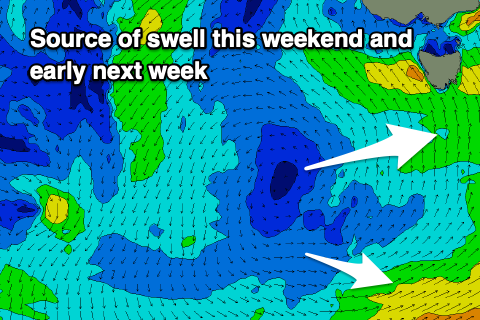
Some better S’ly swell is due into early next week, generated by good fetches of S/SW winds projecting up from the polar shelf on the weekend and into Monday, on the backside of the low.
This should produce 2ft+ waves through later Monday but more so Tuesday, easing into the afternoon and then down from 1-2ft on Wednesday.
Local winds should improve on Monday, shifting N/NW with S/SE swell in the 2ft+ range, while the afternoon will become bumpy with SE sea breezes.
N/NW tending N/NE winds are due on Tuesday with the S’ly swell, shifting W/NW-NW on Wednesday as the energy eases.
Longer term a mid-latitude frontal system moving in later week may generate some fun new W/SW swell but we’ll review this on Monday. Have a great weekend!

