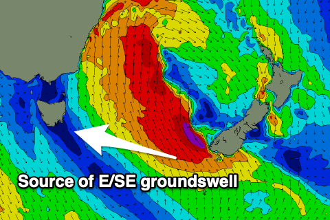
E/SE swell dominates this week
Southern Tasmanian Surf Forecast by Craig Brokensha (issued Monday July 29th)
Best Days: Wednesday, Thursday
Features of the Forecast (tl;dr)
- Small E/SE groundswell building later tomorrow, peaking Wed, easing Thu
- N/NE-N tending N/NE winds Wed and Thu
- Inconsistent W/SW groundswell Thu, fading Fri with strengthening N/NE winds
Recap
Saturday offered small, inconsistent 1-2ft sets, a little better than expected while a poor quality S’ly windswell was kicked up yesterday along with onshore winds.
Today the S’ly windswell is fading with offshore winds, coming in at 1-1.5ft.
This week and weekend (Jul 30 - Aug 4)
The week ahead revolves around a broad, significant low sitting in the southern Tasman Sea, and we’ve got an improvement in the wind outlook as it stays at arms length from us.
The low has already formed, with a fetch of SE gales being just within our swell window, resulting in E/SE energy spreading radially out from the fetch.
We’ll see this fetch strengthen this afternoon and evening, reaching severe-gale before easing slowly tomorrow but persisting into Wednesday before fading Thursday.
What this should result in is a fun run of E/SE swell energy, building tomorrow afternoon but being more reliable and visible on Wednesday.

Clifton should see 2ft+ sets Wednesday, bigger down Storm Bay and with a N-N/NW tending N/NE breeze.
Similar winds are due on Thursday but with easing 2ft sets from the E/SE.
We’re also due to see some distant W/SW groundswell, generated mostly too far north of our swell window by a significant storm that’s south-west of Western Australia.
2ft sets are due, easing into Friday along with E/SE energy to 1.5ft.
Winds will strengthen from the N/NE on Friday favouring some spots over others.
Longer term there’s nothing major due until mid-next week so try and work the coming E/SE swell energy.

