Poor weekend, tricky next week
Southern Tasmanian Surf Forecast by Craig Brokensha (issued Friday July 26th)
Best Days: Possible days next week depending on wind outlook
Features of the Forecast (tl;dr)
- Fading swell tomorrow with N/NW tending variable winds
- Strong SW tending S/SW winds Sun with a weak S windswell
- Easing windswell Mon with W/SW tending S/SW winds (possibly W/NW early)
- Moderate sized E/SE groundswell for Wed, easing Thu but with winds unknown
Recap
The surf bottomed out yesterday, but this morning we’ve seen a small W/SW swell come in at 1-2ft on the rare set. Otherwise it’s still mostly tiny and a bit bumpy with north winds.
This weekend and next week (Jul 27 - Aug 2)
The weekend’s flukey swell now looks less likely, owing to a strong mid-latitude low that’s moving in from the west today, expelling all its energy north of our swell window.
Once it track east-southeast and under us tomorrow, it’s due to have no strength with no spike in swell late tomorrow, while Sunday may see a tiny weak S windswell.
Conditions will be clean tomorrow with a N/NW offshore, tending variable while strong SW tending S/SW winds are due Sunday as we fall under the backside of the low.

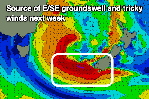
Now, looking at next week and our outlook will be dominated by a significant, stalling low in the southern Tasman Sea.
Much like the system seem a month ago, we’re due to fall under the influence of the lows western arm, with strong onshore S - SE winds due along with some sizey E/SE groundswell.
The groundswell will be generated be a fetch of gale to severe-gale E/SE winds firing up west of New Zealand’s South Island early next week, generating large to extra-large surf for the East Coast, moderate in size inside Storm Bay. More exposed breaks should actually come in large.
A peak in swell is due Wednesday, easing slowly Thursday but with winds not quite locked in yet. GFS has the low retrograding back to the west, bringing onshore S/SE winds, but EC has it further east, leading to local offshore winds.
With this we’ll have to look at the expected size and conditions next Monday. Have a great weekend!

